You are here: Home > Network List > GS - US Geological Survey Networks Stations List
> Station DEC07 Decatur Surface Seismic Site, Decatur, IL, USA > Earthquake Result Viewer
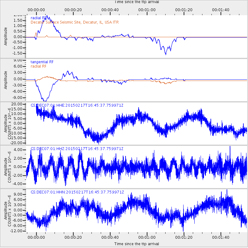
DEC07 Decatur Surface Seismic Site, Decatur, IL, USA - Earthquake Result Viewer
*The percent match for this event was below the threshold and hence no stack was calculated.
| Earthquake location: |
Off East Coast Of Honshu, Japan |
| Earthquake latitude/longitude: |
39.6/143.6 |
| Earthquake time(UTC): |
2015/02/17 (048) 16:33:21 GMT |
| Earthquake Depth: |
10 km |
| Earthquake Magnitude: |
5.5 MWW, 5.5 MWC, 5.5 MWB |
| Earthquake Catalog/Contributor: |
NEIC PDE/NEIC COMCAT |
|
| Network: |
GS US Geological Survey Networks |
| Station: |
DEC07 Decatur Surface Seismic Site, Decatur, IL, USA |
| Lat/Lon: |
39.86 N/88.90 W |
| Elevation: |
212 m |
|
| Distance: |
87.5 deg |
| Az: |
37.663 deg |
| Baz: |
322.151 deg |
| Ray Param: |
$rayparam |
*The percent match for this event was below the threshold and hence was not used in the summary stack. |
|
| Radial Match: |
27.232752 % |
| Radial Bump: |
400 |
| Transverse Match: |
27.373363 % |
| Transverse Bump: |
400 |
| SOD ConfigId: |
872571 |
| Insert Time: |
2015-03-22 21:05:01.938 +0000 |
| GWidth: |
2.5 |
| Max Bumps: |
400 |
| Tol: |
0.001 |
|
Signal To Noise
| Channel | StoN | STA | LTA |
| GS:DEC07:01:HHZ:20150217T16:45:37.759971Z | 1.4345479 | 1.7781314E-6 | 1.2395064E-6 |
| GS:DEC07:01:HHN:20150217T16:45:37.759971Z | 3.4125872 | 8.71391E-6 | 2.5534616E-6 |
| GS:DEC07:01:HHE:20150217T16:45:37.759971Z | 4.211931 | 2.0615538E-5 | 4.894557E-6 |
| Arrivals |
| Ps | |
| PpPs | |
| PsPs/PpSs | |


