You are here: Home > Network List > IU - Global Seismograph Network (GSN - IRIS/USGS) Stations List
> Station FURI Mt. Furi, Ethiopia > Earthquake Result Viewer
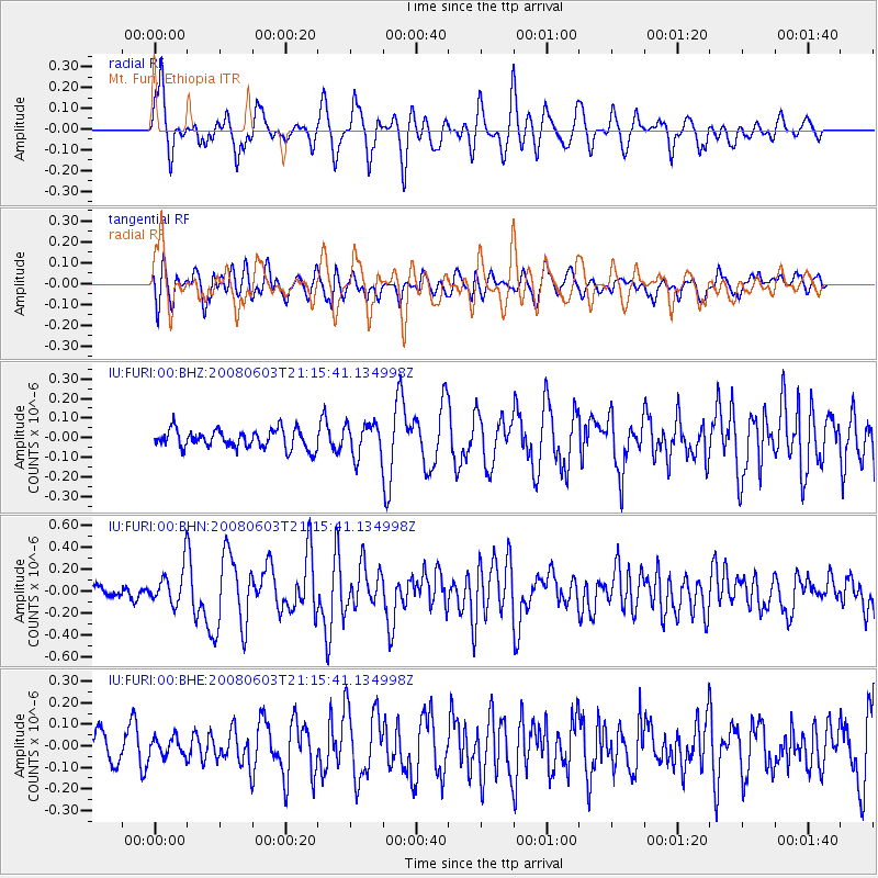
FURI Mt. Furi, Ethiopia - Earthquake Result Viewer
*The percent match for this event was below the threshold and hence no stack was calculated.
| Earthquake location: |
Flores Region, Indonesia |
| Earthquake latitude/longitude: |
-8.1/120.3 |
| Earthquake time(UTC): |
2008/06/03 (155) 21:03:46 GMT |
| Earthquake Depth: |
7.0 km |
| Earthquake Magnitude: |
5.5 MB, 5.2 MS, 5.8 MW, 5.7 MW |
| Earthquake Catalog/Contributor: |
WHDF/NEIC |
|
| Network: |
IU Global Seismograph Network (GSN - IRIS/USGS) |
| Station: |
FURI Mt. Furi, Ethiopia |
| Lat/Lon: |
8.90 N/38.68 E |
| Elevation: |
2570 m |
|
| Distance: |
83.0 deg |
| Az: |
280.002 deg |
| Baz: |
99.335 deg |
| Ray Param: |
$rayparam |
*The percent match for this event was below the threshold and hence was not used in the summary stack. |
|
| Radial Match: |
73.62418 % |
| Radial Bump: |
400 |
| Transverse Match: |
60.368626 % |
| Transverse Bump: |
400 |
| SOD ConfigId: |
2504 |
| Insert Time: |
2010-03-03 16:27:18.513 +0000 |
| GWidth: |
2.5 |
| Max Bumps: |
400 |
| Tol: |
0.001 |
|
Signal To Noise
| Channel | StoN | STA | LTA |
| IU:FURI:00:BHN:20080603T21:15:41.134998Z | 1.9928185 | 1.769192E-7 | 8.8778386E-8 |
| IU:FURI:00:BHE:20080603T21:15:41.134998Z | 0.4610938 | 4.122151E-8 | 8.93994E-8 |
| IU:FURI:00:BHZ:20080603T21:15:41.134998Z | 1.7731233 | 8.36949E-8 | 4.7201965E-8 |
| Arrivals |
| Ps | |
| PpPs | |
| PsPs/PpSs | |


