You are here: Home > Network List > GS - US Geological Survey Networks Stations List
> Station KAN08 Pence Farm, Harper, KS, USA > Earthquake Result Viewer
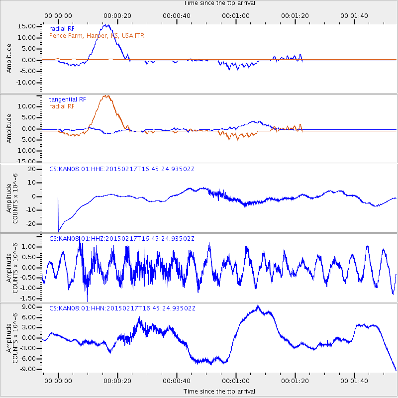
KAN08 Pence Farm, Harper, KS, USA - Earthquake Result Viewer
*The percent match for this event was below the threshold and hence no stack was calculated.
| Earthquake location: |
Off East Coast Of Honshu, Japan |
| Earthquake latitude/longitude: |
39.6/143.6 |
| Earthquake time(UTC): |
2015/02/17 (048) 16:33:21 GMT |
| Earthquake Depth: |
10 km |
| Earthquake Magnitude: |
5.5 MWW, 5.5 MWC, 5.5 MWB |
| Earthquake Catalog/Contributor: |
NEIC PDE/NEIC COMCAT |
|
| Network: |
GS US Geological Survey Networks |
| Station: |
KAN08 Pence Farm, Harper, KS, USA |
| Lat/Lon: |
37.23 N/97.97 W |
| Elevation: |
375 m |
|
| Distance: |
84.9 deg |
| Az: |
44.795 deg |
| Baz: |
316.981 deg |
| Ray Param: |
$rayparam |
*The percent match for this event was below the threshold and hence was not used in the summary stack. |
|
| Radial Match: |
65.34998 % |
| Radial Bump: |
400 |
| Transverse Match: |
10.639157 % |
| Transverse Bump: |
400 |
| SOD ConfigId: |
872571 |
| Insert Time: |
2015-03-22 21:05:24.629 +0000 |
| GWidth: |
2.5 |
| Max Bumps: |
400 |
| Tol: |
0.001 |
|
Signal To Noise
| Channel | StoN | STA | LTA |
| GS:KAN08:01:HHZ:20150217T16:45:24.93502Z | 1.5111097 | 5.558385E-7 | 3.678346E-7 |
| GS:KAN08:01:HHN:20150217T16:45:24.93502Z | 0.34381455 | 1.8027873E-6 | 5.2434875E-6 |
| GS:KAN08:01:HHE:20150217T16:45:24.93502Z | 0.34122863 | 2.6697999E-6 | 7.824079E-6 |
| Arrivals |
| Ps | |
| PpPs | |
| PsPs/PpSs | |


