You are here: Home > Network List > IU - Global Seismograph Network (GSN - IRIS/USGS) Stations List
> Station FURI Mt. Furi, Ethiopia > Earthquake Result Viewer
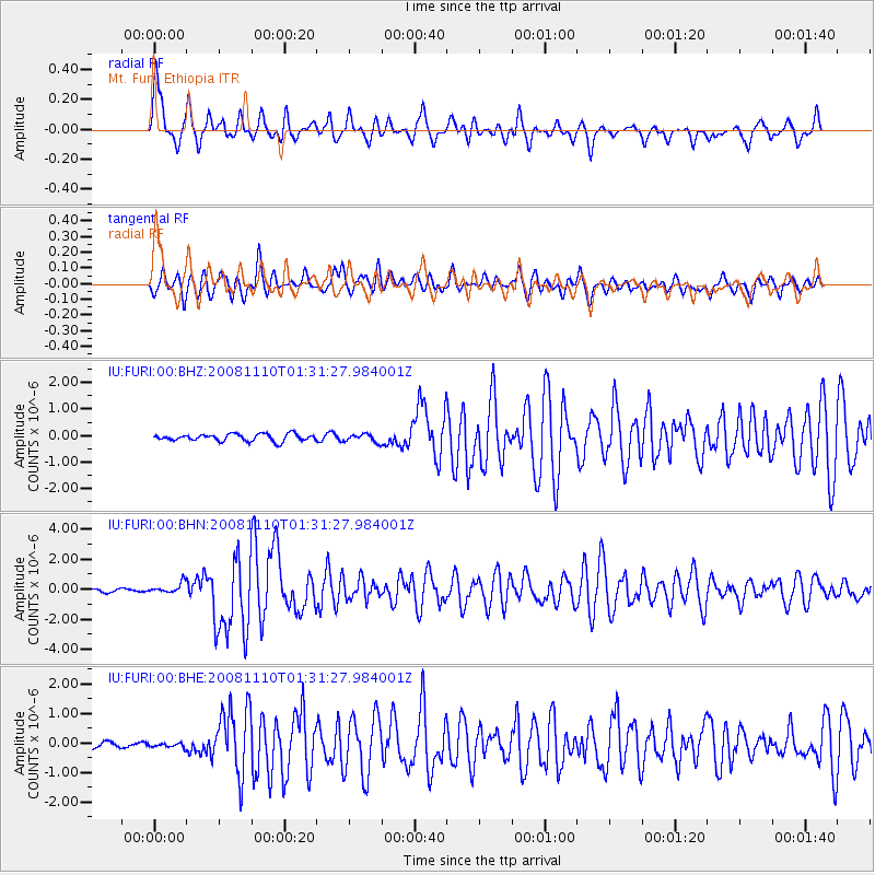
FURI Mt. Furi, Ethiopia - Earthquake Result Viewer
*The percent match for this event was below the threshold and hence no stack was calculated.
| Earthquake location: |
Qinghai, China |
| Earthquake latitude/longitude: |
37.6/95.8 |
| Earthquake time(UTC): |
2008/11/10 (315) 01:22:02 GMT |
| Earthquake Depth: |
19 km |
| Earthquake Magnitude: |
6.4 MB, 6.4 MS, 6.3 MW, 6.3 MW |
| Earthquake Catalog/Contributor: |
WHDF/NEIC |
|
| Network: |
IU Global Seismograph Network (GSN - IRIS/USGS) |
| Station: |
FURI Mt. Furi, Ethiopia |
| Lat/Lon: |
8.90 N/38.68 E |
| Elevation: |
2570 m |
|
| Distance: |
58.7 deg |
| Az: |
256.239 deg |
| Baz: |
51.361 deg |
| Ray Param: |
$rayparam |
*The percent match for this event was below the threshold and hence was not used in the summary stack. |
|
| Radial Match: |
76.98904 % |
| Radial Bump: |
400 |
| Transverse Match: |
68.3638 % |
| Transverse Bump: |
400 |
| SOD ConfigId: |
2658 |
| Insert Time: |
2010-03-03 16:27:28.268 +0000 |
| GWidth: |
2.5 |
| Max Bumps: |
400 |
| Tol: |
0.001 |
|
Signal To Noise
| Channel | StoN | STA | LTA |
| IU:FURI:00:BHN:20081110T01:31:27.984001Z | 3.274143 | 3.4010625E-7 | 1.03876424E-7 |
| IU:FURI:00:BHE:20081110T01:31:27.984001Z | 0.67372406 | 7.286768E-8 | 1.0815656E-7 |
| IU:FURI:00:BHZ:20081110T01:31:27.984001Z | 1.1558442 | 1.522121E-7 | 1.3168912E-7 |
| Arrivals |
| Ps | |
| PpPs | |
| PsPs/PpSs | |


