You are here: Home > Network List > IU - Global Seismograph Network (GSN - IRIS/USGS) Stations List
> Station FURI Mt. Furi, Ethiopia > Earthquake Result Viewer
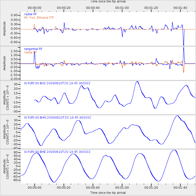
FURI Mt. Furi, Ethiopia - Earthquake Result Viewer
*The percent match for this event was below the threshold and hence no stack was calculated.
| Earthquake location: |
Near S. Coast Of Honshu, Japan |
| Earthquake latitude/longitude: |
34.7/138.3 |
| Earthquake time(UTC): |
2009/08/10 (222) 20:07:09 GMT |
| Earthquake Depth: |
40 km |
| Earthquake Magnitude: |
6.1 MB |
| Earthquake Catalog/Contributor: |
WHDF/NEIC |
|
| Network: |
IU Global Seismograph Network (GSN - IRIS/USGS) |
| Station: |
FURI Mt. Furi, Ethiopia |
| Lat/Lon: |
8.90 N/38.68 E |
| Elevation: |
2570 m |
|
| Distance: |
92.8 deg |
| Az: |
282.715 deg |
| Baz: |
54.386 deg |
| Ray Param: |
$rayparam |
*The percent match for this event was below the threshold and hence was not used in the summary stack. |
|
| Radial Match: |
44.28104 % |
| Radial Bump: |
362 |
| Transverse Match: |
42.48383 % |
| Transverse Bump: |
342 |
| SOD ConfigId: |
2622 |
| Insert Time: |
2010-03-03 16:27:30.614 +0000 |
| GWidth: |
2.5 |
| Max Bumps: |
400 |
| Tol: |
0.001 |
|
Signal To Noise
| Channel | StoN | STA | LTA |
| IU:FURI:00:BHN:20090810T20:19:45.90303Z | 1.9855801 | 2.2589713E-5 | 1.1376883E-5 |
| IU:FURI:00:BHE:20090810T20:19:45.90303Z | 2.3328626 | 7.7189376E-5 | 3.3087836E-5 |
| IU:FURI:00:BHZ:20090810T20:19:45.90303Z | 3.8542566 | 2.296302E-5 | 5.9578338E-6 |
| Arrivals |
| Ps | |
| PpPs | |
| PsPs/PpSs | |


