You are here: Home > Network List > IU - Global Seismograph Network (GSN - IRIS/USGS) Stations List
> Station FURI Mt. Furi, Ethiopia > Earthquake Result Viewer
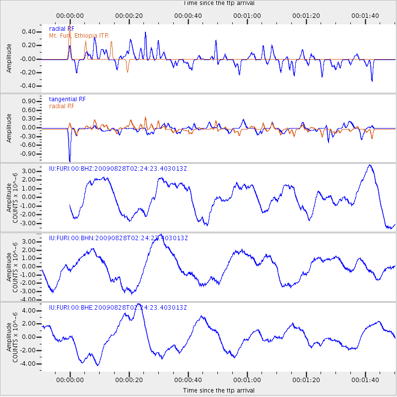
FURI Mt. Furi, Ethiopia - Earthquake Result Viewer
*The percent match for this event was below the threshold and hence no stack was calculated.
| Earthquake location: |
Qinghai, China |
| Earthquake latitude/longitude: |
37.6/95.7 |
| Earthquake time(UTC): |
2009/08/28 (240) 02:14:56 GMT |
| Earthquake Depth: |
4.0 km |
| Earthquake Magnitude: |
5.6 MB |
| Earthquake Catalog/Contributor: |
WHDF/NEIC |
|
| Network: |
IU Global Seismograph Network (GSN - IRIS/USGS) |
| Station: |
FURI Mt. Furi, Ethiopia |
| Lat/Lon: |
8.90 N/38.68 E |
| Elevation: |
2570 m |
|
| Distance: |
58.6 deg |
| Az: |
256.102 deg |
| Baz: |
51.242 deg |
| Ray Param: |
$rayparam |
*The percent match for this event was below the threshold and hence was not used in the summary stack. |
|
| Radial Match: |
72.42134 % |
| Radial Bump: |
400 |
| Transverse Match: |
64.96807 % |
| Transverse Bump: |
400 |
| SOD ConfigId: |
2622 |
| Insert Time: |
2010-03-03 16:27:33.275 +0000 |
| GWidth: |
2.5 |
| Max Bumps: |
400 |
| Tol: |
0.001 |
|
Signal To Noise
| Channel | StoN | STA | LTA |
| IU:FURI:00:BHN:20090828T02:24:23.403013Z | 0.58819973 | 7.5998804E-7 | 1.2920577E-6 |
| IU:FURI:00:BHE:20090828T02:24:23.403013Z | 1.7585801 | 2.6499754E-6 | 1.5068836E-6 |
| IU:FURI:00:BHZ:20090828T02:24:23.403013Z | 1.1387086 | 2.0366465E-6 | 1.788558E-6 |
| Arrivals |
| Ps | |
| PpPs | |
| PsPs/PpSs | |


