You are here: Home > Network List > IU - Global Seismograph Network (GSN - IRIS/USGS) Stations List
> Station FURI Mt. Furi, Ethiopia > Earthquake Result Viewer
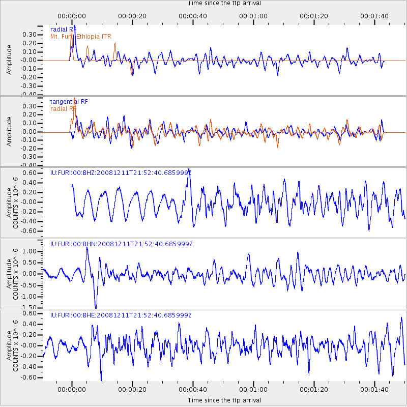
FURI Mt. Furi, Ethiopia - Earthquake Result Viewer
*The percent match for this event was below the threshold and hence no stack was calculated.
| Earthquake location: |
Minahassa Peninsula, Sulawesi |
| Earthquake latitude/longitude: |
0.1/123.4 |
| Earthquake time(UTC): |
2008/12/11 (346) 21:40:52 GMT |
| Earthquake Depth: |
133 km |
| Earthquake Magnitude: |
6.1 MB, 5.9 MW, 5.9 MW |
| Earthquake Catalog/Contributor: |
WHDF/NEIC |
|
| Network: |
IU Global Seismograph Network (GSN - IRIS/USGS) |
| Station: |
FURI Mt. Furi, Ethiopia |
| Lat/Lon: |
8.90 N/38.68 E |
| Elevation: |
2570 m |
|
| Distance: |
84.8 deg |
| Az: |
278.868 deg |
| Baz: |
90.75 deg |
| Ray Param: |
$rayparam |
*The percent match for this event was below the threshold and hence was not used in the summary stack. |
|
| Radial Match: |
47.186012 % |
| Radial Bump: |
400 |
| Transverse Match: |
66.818245 % |
| Transverse Bump: |
400 |
| SOD ConfigId: |
2658 |
| Insert Time: |
2010-03-03 16:27:46.639 +0000 |
| GWidth: |
2.5 |
| Max Bumps: |
400 |
| Tol: |
0.001 |
|
Signal To Noise
| Channel | StoN | STA | LTA |
| IU:FURI:00:BHN:20081211T21:52:40.685999Z | 1.9381388 | 2.9490025E-7 | 1.5215642E-7 |
| IU:FURI:00:BHE:20081211T21:52:40.685999Z | 0.7328225 | 8.173693E-8 | 1.1153715E-7 |
| IU:FURI:00:BHZ:20081211T21:52:40.685999Z | 0.4989075 | 1.071778E-7 | 2.1482498E-7 |
| Arrivals |
| Ps | |
| PpPs | |
| PsPs/PpSs | |


