You are here: Home > Network List > IU - Global Seismograph Network (GSN - IRIS/USGS) Stations List
> Station FURI Mt. Furi, Ethiopia > Earthquake Result Viewer
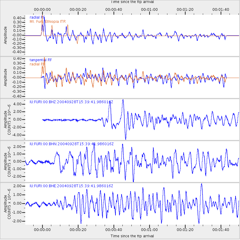
FURI Mt. Furi, Ethiopia - Earthquake Result Viewer
*The percent match for this event was below the threshold and hence no stack was calculated.
| Earthquake location: |
South Of Africa |
| Earthquake latitude/longitude: |
-52.5/28.0 |
| Earthquake time(UTC): |
2004/09/28 (272) 15:29:53 GMT |
| Earthquake Depth: |
10 km |
| Earthquake Magnitude: |
5.9 MB, 6.0 MS, 6.4 MW, 6.3 MW |
| Earthquake Catalog/Contributor: |
WHDF/NEIC |
|
| Network: |
IU Global Seismograph Network (GSN - IRIS/USGS) |
| Station: |
FURI Mt. Furi, Ethiopia |
| Lat/Lon: |
8.90 N/38.68 E |
| Elevation: |
2570 m |
|
| Distance: |
61.8 deg |
| Az: |
11.969 deg |
| Baz: |
187.369 deg |
| Ray Param: |
$rayparam |
*The percent match for this event was below the threshold and hence was not used in the summary stack. |
|
| Radial Match: |
88.7132 % |
| Radial Bump: |
400 |
| Transverse Match: |
82.19175 % |
| Transverse Bump: |
400 |
| SOD ConfigId: |
2459 |
| Insert Time: |
2010-03-03 16:27:47.518 +0000 |
| GWidth: |
2.5 |
| Max Bumps: |
400 |
| Tol: |
0.001 |
|
Signal To Noise
| Channel | StoN | STA | LTA |
| IU:FURI:00:BHN:20040928T15:39:41.986016Z | 0.6183394 | 1.10808855E-7 | 1.7920392E-7 |
| IU:FURI:00:BHE:20040928T15:39:41.986016Z | 1.173769 | 1.2032638E-7 | 1.02512836E-7 |
| IU:FURI:00:BHZ:20040928T15:39:41.986016Z | 5.2163496 | 5.170025E-7 | 9.911193E-8 |
| Arrivals |
| Ps | |
| PpPs | |
| PsPs/PpSs | |


