You are here: Home > Network List > IU - Global Seismograph Network (GSN - IRIS/USGS) Stations List
> Station FURI Mt. Furi, Ethiopia > Earthquake Result Viewer
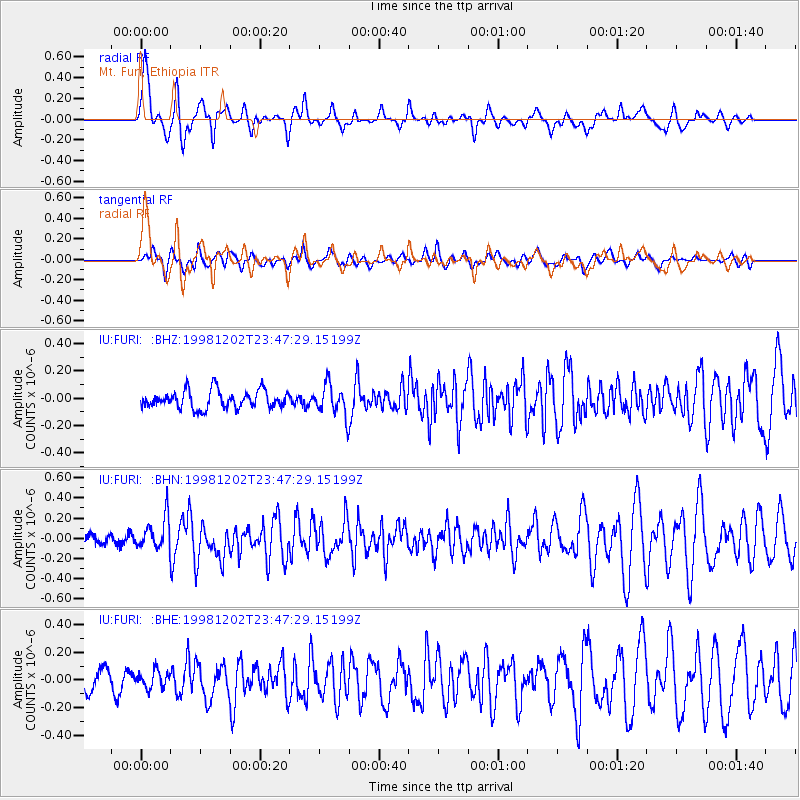
FURI Mt. Furi, Ethiopia - Earthquake Result Viewer
*The percent match for this event was below the threshold and hence no stack was calculated.
| Earthquake location: |
Mid-Indian Ridge |
| Earthquake latitude/longitude: |
-9.1/67.5 |
| Earthquake time(UTC): |
1998/12/02 (336) 23:41:17 GMT |
| Earthquake Depth: |
10 km |
| Earthquake Magnitude: |
5.9 UNKNOWN, 5.2 MS, 5.0 MB, 5.7 MW |
| Earthquake Catalog/Contributor: |
WHDF/NEIC |
|
| Network: |
IU Global Seismograph Network (GSN - IRIS/USGS) |
| Station: |
FURI Mt. Furi, Ethiopia |
| Lat/Lon: |
8.90 N/38.68 E |
| Elevation: |
2570 m |
|
| Distance: |
33.8 deg |
| Az: |
301.228 deg |
| Baz: |
121.292 deg |
| Ray Param: |
$rayparam |
*The percent match for this event was below the threshold and hence was not used in the summary stack. |
|
| Radial Match: |
72.59549 % |
| Radial Bump: |
372 |
| Transverse Match: |
62.332344 % |
| Transverse Bump: |
400 |
| SOD ConfigId: |
4480 |
| Insert Time: |
2010-03-03 16:27:51.717 +0000 |
| GWidth: |
2.5 |
| Max Bumps: |
400 |
| Tol: |
0.001 |
|
Signal To Noise
| Channel | StoN | STA | LTA |
| IU:FURI: :BHN:19981202T23:47:29.15199Z | 1.9569621 | 1.5674458E-7 | 8.009586E-8 |
| IU:FURI: :BHE:19981202T23:47:29.15199Z | 0.89077634 | 6.160506E-8 | 6.915884E-8 |
| IU:FURI: :BHZ:19981202T23:47:29.15199Z | 1.7175218 | 1.12137855E-7 | 6.529049E-8 |
| Arrivals |
| Ps | |
| PpPs | |
| PsPs/PpSs | |


