You are here: Home > Network List > IU - Global Seismograph Network (GSN - IRIS/USGS) Stations List
> Station FURI Mt. Furi, Ethiopia > Earthquake Result Viewer
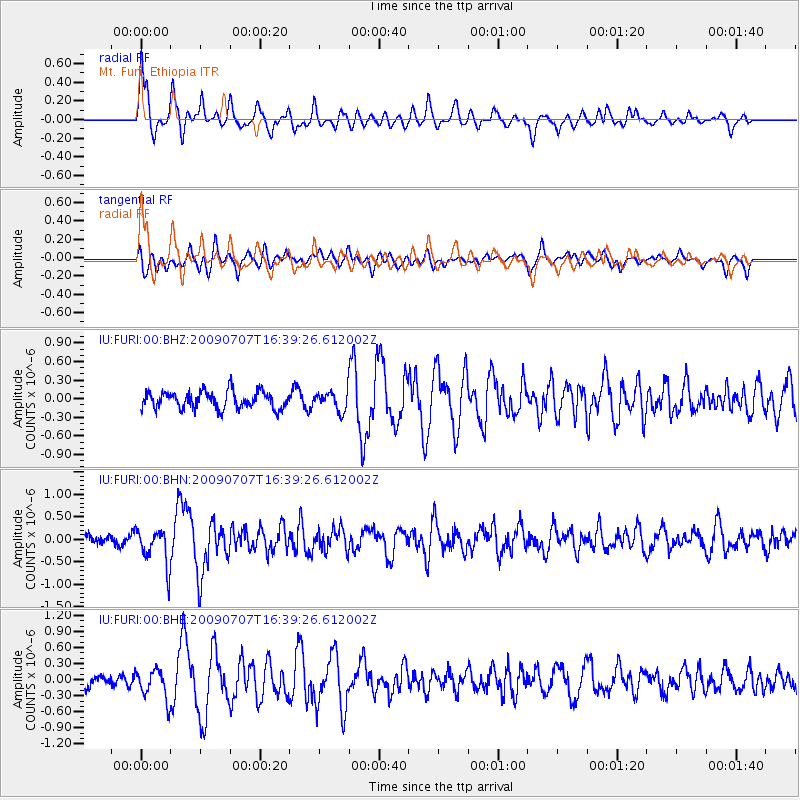
FURI Mt. Furi, Ethiopia - Earthquake Result Viewer
*The percent match for this event was below the threshold and hence no stack was calculated.
| Earthquake location: |
Indian Ocean Triple Junction |
| Earthquake latitude/longitude: |
-26.7/67.5 |
| Earthquake time(UTC): |
2009/07/07 (188) 16:31:41 GMT |
| Earthquake Depth: |
10 km |
| Earthquake Magnitude: |
5.6 MB, 5.1 MS, 5.7 MW, 5.5 MW |
| Earthquake Catalog/Contributor: |
WHDF/NEIC |
|
| Network: |
IU Global Seismograph Network (GSN - IRIS/USGS) |
| Station: |
FURI Mt. Furi, Ethiopia |
| Lat/Lon: |
8.90 N/38.68 E |
| Elevation: |
2570 m |
|
| Distance: |
45.1 deg |
| Az: |
317.797 deg |
| Baz: |
142.559 deg |
| Ray Param: |
$rayparam |
*The percent match for this event was below the threshold and hence was not used in the summary stack. |
|
| Radial Match: |
75.00059 % |
| Radial Bump: |
400 |
| Transverse Match: |
61.282436 % |
| Transverse Bump: |
400 |
| SOD ConfigId: |
2648 |
| Insert Time: |
2010-03-03 16:27:55.341 +0000 |
| GWidth: |
2.5 |
| Max Bumps: |
400 |
| Tol: |
0.001 |
|
Signal To Noise
| Channel | StoN | STA | LTA |
| IU:FURI:00:BHN:20090707T16:39:26.612002Z | 4.1670876 | 4.2355367E-7 | 1.0164262E-7 |
| IU:FURI:00:BHE:20090707T16:39:26.612002Z | 1.8694813 | 2.8263048E-7 | 1.5118123E-7 |
| IU:FURI:00:BHZ:20090707T16:39:26.612002Z | 1.1040796 | 1.5505971E-7 | 1.4044251E-7 |
| Arrivals |
| Ps | |
| PpPs | |
| PsPs/PpSs | |


