You are here: Home > Network List > IU - Global Seismograph Network (GSN - IRIS/USGS) Stations List
> Station FURI Mt. Furi, Ethiopia > Earthquake Result Viewer
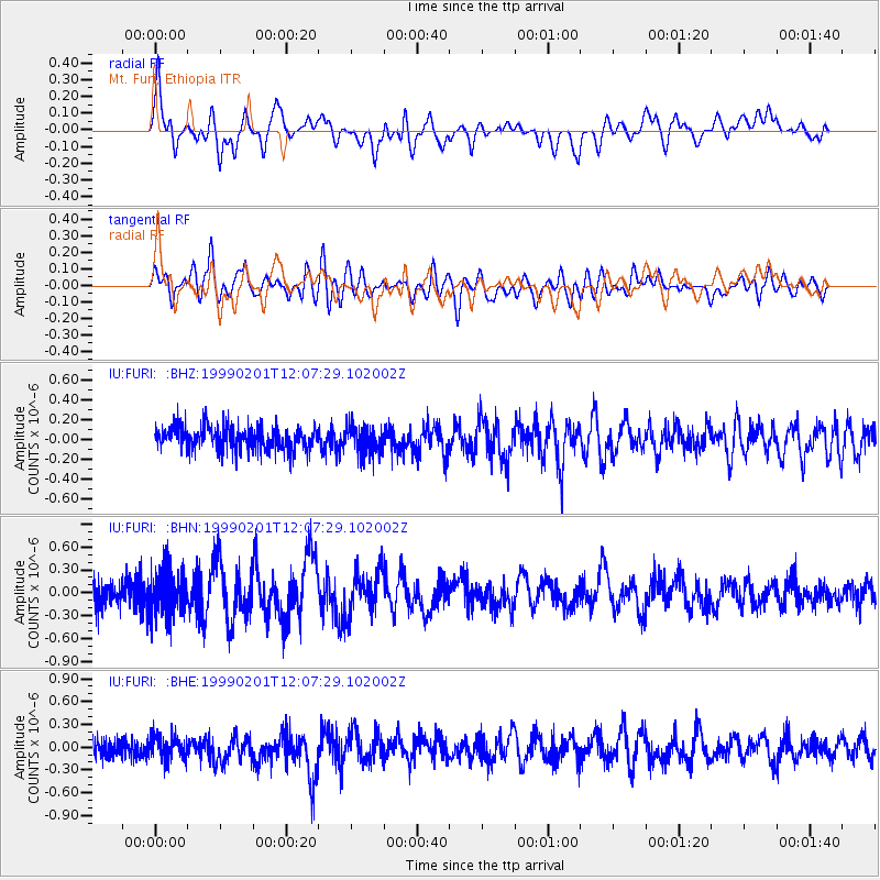
FURI Mt. Furi, Ethiopia - Earthquake Result Viewer
*The percent match for this event was below the threshold and hence no stack was calculated.
| Earthquake location: |
North Of Severnaya Zemlya |
| Earthquake latitude/longitude: |
85.6/87.1 |
| Earthquake time(UTC): |
1999/02/01 (032) 11:56:00 GMT |
| Earthquake Depth: |
10 km |
| Earthquake Magnitude: |
5.5 MS, 5.1 MB, 5.8 MW, 5.7 MW |
| Earthquake Catalog/Contributor: |
WHDF/NEIC |
|
| Network: |
IU Global Seismograph Network (GSN - IRIS/USGS) |
| Station: |
FURI Mt. Furi, Ethiopia |
| Lat/Lon: |
8.90 N/38.68 E |
| Elevation: |
2570 m |
|
| Distance: |
78.2 deg |
| Az: |
229.071 deg |
| Baz: |
3.408 deg |
| Ray Param: |
$rayparam |
*The percent match for this event was below the threshold and hence was not used in the summary stack. |
|
| Radial Match: |
70.9727 % |
| Radial Bump: |
400 |
| Transverse Match: |
67.014656 % |
| Transverse Bump: |
400 |
| SOD ConfigId: |
4480 |
| Insert Time: |
2010-03-03 16:27:57.039 +0000 |
| GWidth: |
2.5 |
| Max Bumps: |
400 |
| Tol: |
0.001 |
|
Signal To Noise
| Channel | StoN | STA | LTA |
| IU:FURI: :BHN:19990201T12:07:29.102002Z | 1.6529946 | 3.141399E-7 | 1.9004291E-7 |
| IU:FURI: :BHE:19990201T12:07:29.102002Z | 0.8140098 | 1.508013E-7 | 1.8525735E-7 |
| IU:FURI: :BHZ:19990201T12:07:29.102002Z | 1.1874856 | 1.4315881E-7 | 1.2055627E-7 |
| Arrivals |
| Ps | |
| PpPs | |
| PsPs/PpSs | |


