You are here: Home > Network List > IU - Global Seismograph Network (GSN - IRIS/USGS) Stations List
> Station FURI Mt. Furi, Ethiopia > Earthquake Result Viewer
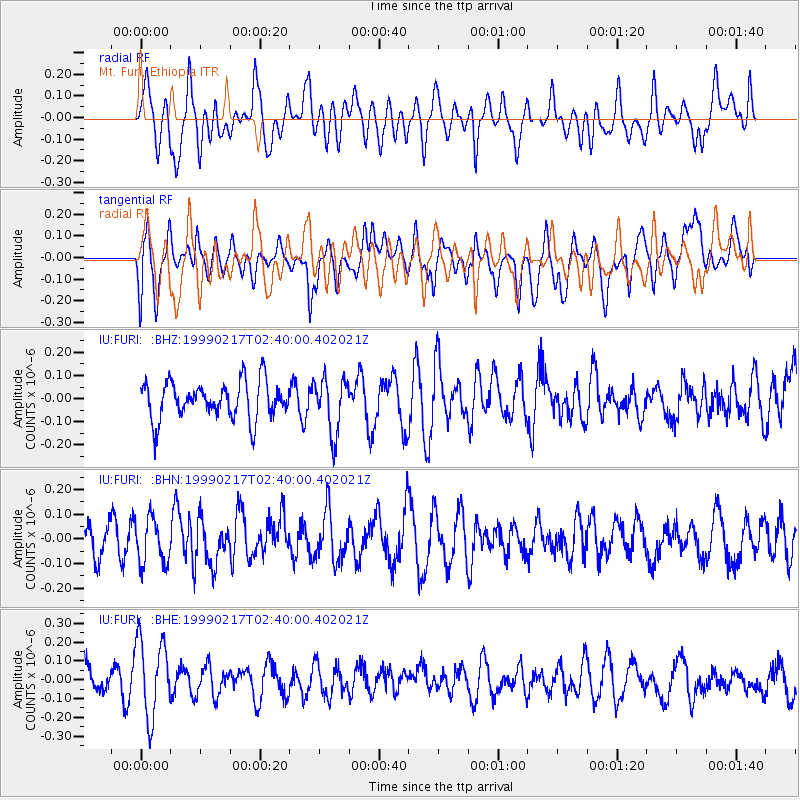
FURI Mt. Furi, Ethiopia - Earthquake Result Viewer
*The percent match for this event was below the threshold and hence no stack was calculated.
| Earthquake location: |
Irian Jaya Region, Indonesia |
| Earthquake latitude/longitude: |
-2.0/133.5 |
| Earthquake time(UTC): |
1999/02/17 (048) 02:27:12 GMT |
| Earthquake Depth: |
33 km |
| Earthquake Magnitude: |
5.7 MW, 5.4 MS, 5.4 MB, 5.6 MW |
| Earthquake Catalog/Contributor: |
WHDF/NEIC |
|
| Network: |
IU Global Seismograph Network (GSN - IRIS/USGS) |
| Station: |
FURI Mt. Furi, Ethiopia |
| Lat/Lon: |
8.90 N/38.68 E |
| Elevation: |
2570 m |
|
| Distance: |
95.1 deg |
| Az: |
278.698 deg |
| Baz: |
91.242 deg |
| Ray Param: |
$rayparam |
*The percent match for this event was below the threshold and hence was not used in the summary stack. |
|
| Radial Match: |
47.86772 % |
| Radial Bump: |
400 |
| Transverse Match: |
53.20856 % |
| Transverse Bump: |
400 |
| SOD ConfigId: |
4480 |
| Insert Time: |
2010-03-03 16:27:58.799 +0000 |
| GWidth: |
2.5 |
| Max Bumps: |
400 |
| Tol: |
0.001 |
|
Signal To Noise
| Channel | StoN | STA | LTA |
| IU:FURI: :BHN:19990217T02:40:00.402021Z | 1.2667644 | 9.200813E-8 | 7.2632396E-8 |
| IU:FURI: :BHE:19990217T02:40:00.402021Z | 2.5450635 | 2.1107152E-7 | 8.2933695E-8 |
| IU:FURI: :BHZ:19990217T02:40:00.402021Z | 1.4852017 | 1.1950782E-7 | 8.046572E-8 |
| Arrivals |
| Ps | |
| PpPs | |
| PsPs/PpSs | |


