You are here: Home > Network List > XL12 - Hangay Dome, Mongolia Stations List
> Station HV31 HV31 > Earthquake Result Viewer
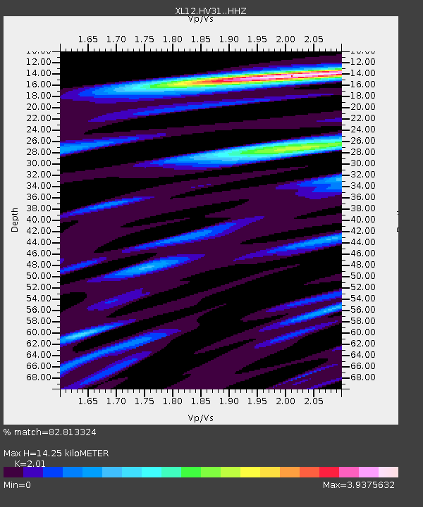
HV31 HV31 - Earthquake Result Viewer
| Earthquake location: |
Pakistan |
| Earthquake latitude/longitude: |
27.4/66.0 |
| Earthquake time(UTC): |
2015/07/15 (196) 11:25:59 GMT |
| Earthquake Depth: |
10 km |
| Earthquake Magnitude: |
5.5 MB, 5.1 MWB, 5.3 MWC, 5.3 MWW |
| Earthquake Catalog/Contributor: |
NEIC PDE/NEIC COMCAT |
|
| Network: |
XL Hangay Dome, Mongolia |
| Station: |
HV31 HV31 |
| Lat/Lon: |
51.34 N/100.24 E |
| Elevation: |
1693 m |
|
| Distance: |
35.2 deg |
| Az: |
37.779 deg |
| Baz: |
240.301 deg |
| Ray Param: |
0.07733864 |
| Estimated Moho Depth: |
14.25 km |
| Estimated Crust Vp/Vs: |
2.01 |
| Assumed Crust Vp: |
6.419 km/s |
| Estimated Crust Vs: |
3.194 km/s |
| Estimated Crust Poisson's Ratio: |
0.34 |
|
| Radial Match: |
82.813324 % |
| Radial Bump: |
400 |
| Transverse Match: |
64.22301 % |
| Transverse Bump: |
400 |
| SOD ConfigId: |
7422571 |
| Insert Time: |
2019-04-19 19:33:51.940 +0000 |
| GWidth: |
2.5 |
| Max Bumps: |
400 |
| Tol: |
0.001 |
|

Signal To Noise
| Channel | StoN | STA | LTA |
| XL:HV31: :HHZ:20150715T11:32:22.839009Z | 4.3740635 | 3.3335726E-7 | 7.621225E-8 |
| XL:HV31: :HHN:20150715T11:32:22.839009Z | 1.3029621 | 1.416639E-7 | 1.0872451E-7 |
| XL:HV31: :HHE:20150715T11:32:22.839009Z | 3.569999 | 2.5227752E-7 | 7.066599E-8 |
| Arrivals |
| Ps | 2.4 SECOND |
| PpPs | 6.3 SECOND |
| PsPs/PpSs | 8.6 SECOND |


