You are here: Home > Network List > IU - Global Seismograph Network (GSN - IRIS/USGS) Stations List
> Station FURI Mt. Furi, Ethiopia > Earthquake Result Viewer
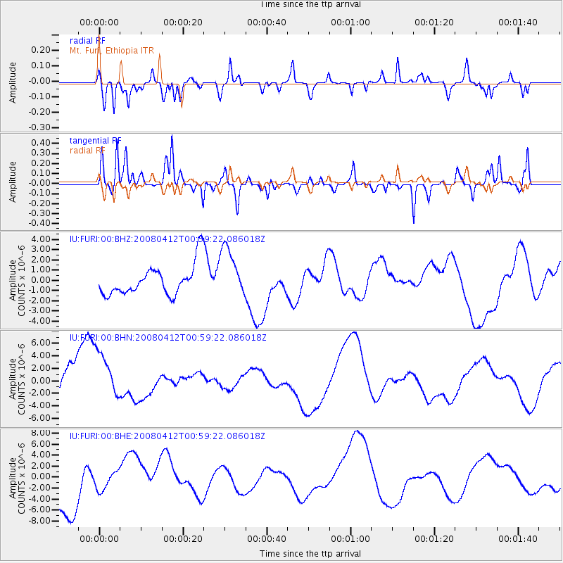
FURI Mt. Furi, Ethiopia - Earthquake Result Viewer
*The percent match for this event was below the threshold and hence no stack was calculated.
| Earthquake location: |
Kuril Islands |
| Earthquake latitude/longitude: |
43.9/147.5 |
| Earthquake time(UTC): |
2008/04/12 (103) 00:46:28 GMT |
| Earthquake Depth: |
64 km |
| Earthquake Magnitude: |
5.7 MB |
| Earthquake Catalog/Contributor: |
WHDF/NEIC |
|
| Network: |
IU Global Seismograph Network (GSN - IRIS/USGS) |
| Station: |
FURI Mt. Furi, Ethiopia |
| Lat/Lon: |
8.90 N/38.68 E |
| Elevation: |
2570 m |
|
| Distance: |
97.1 deg |
| Az: |
289.504 deg |
| Baz: |
43.616 deg |
| Ray Param: |
$rayparam |
*The percent match for this event was below the threshold and hence was not used in the summary stack. |
|
| Radial Match: |
66.61409 % |
| Radial Bump: |
400 |
| Transverse Match: |
53.961365 % |
| Transverse Bump: |
284 |
| SOD ConfigId: |
2504 |
| Insert Time: |
2010-03-03 16:28:03.575 +0000 |
| GWidth: |
2.5 |
| Max Bumps: |
400 |
| Tol: |
0.001 |
|
Signal To Noise
| Channel | StoN | STA | LTA |
| IU:FURI:00:BHN:20080412T00:59:22.086018Z | 1.0312327 | 3.9588845E-6 | 3.8389826E-6 |
| IU:FURI:00:BHE:20080412T00:59:22.086018Z | 0.49330202 | 1.6761268E-6 | 3.3977701E-6 |
| IU:FURI:00:BHZ:20080412T00:59:22.086018Z | 1.677718 | 2.5046681E-6 | 1.4929017E-6 |
| Arrivals |
| Ps | |
| PpPs | |
| PsPs/PpSs | |


