You are here: Home > Network List > IU - Global Seismograph Network (GSN - IRIS/USGS) Stations List
> Station FURI Mt. Furi, Ethiopia > Earthquake Result Viewer
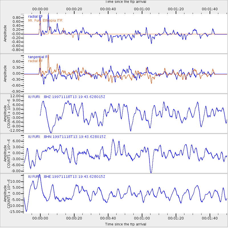
FURI Mt. Furi, Ethiopia - Earthquake Result Viewer
*The percent match for this event was below the threshold and hence no stack was calculated.
| Earthquake location: |
Ionian Sea |
| Earthquake latitude/longitude: |
37.3/20.9 |
| Earthquake time(UTC): |
1997/11/18 (322) 13:13:46 GMT |
| Earthquake Depth: |
33 km |
| Earthquake Magnitude: |
5.5 ML, 5.4 MB |
| Earthquake Catalog/Contributor: |
WHDF/NEIC |
|
| Network: |
IU Global Seismograph Network (GSN - IRIS/USGS) |
| Station: |
FURI Mt. Furi, Ethiopia |
| Lat/Lon: |
8.90 N/38.68 E |
| Elevation: |
2570 m |
|
| Distance: |
32.5 deg |
| Az: |
145.825 deg |
| Baz: |
333.034 deg |
| Ray Param: |
$rayparam |
*The percent match for this event was below the threshold and hence was not used in the summary stack. |
|
| Radial Match: |
54.56206 % |
| Radial Bump: |
400 |
| Transverse Match: |
52.56154 % |
| Transverse Bump: |
400 |
| SOD ConfigId: |
4480 |
| Insert Time: |
2010-03-03 16:28:12.024 +0000 |
| GWidth: |
2.5 |
| Max Bumps: |
400 |
| Tol: |
0.001 |
|
Signal To Noise
| Channel | StoN | STA | LTA |
| IU:FURI: :BHN:19971118T13:19:43.628015Z | 0.5677197 | 1.944673E-6 | 3.4254106E-6 |
| IU:FURI: :BHE:19971118T13:19:43.628015Z | 1.2069197 | 8.635789E-6 | 7.155231E-6 |
| IU:FURI: :BHZ:19971118T13:19:43.628015Z | 0.70040226 | 4.3560344E-6 | 6.2193326E-6 |
| Arrivals |
| Ps | |
| PpPs | |
| PsPs/PpSs | |


