You are here: Home > Network List > TA - USArray Transportable Network (new EarthScope stations) Stations List
> Station I61A Oroboro, Fairlee, VT, USA > Earthquake Result Viewer
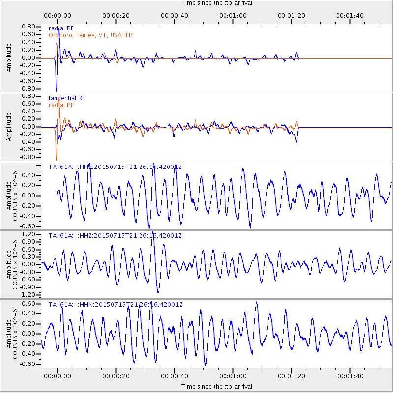
I61A Oroboro, Fairlee, VT, USA - Earthquake Result Viewer
*The percent match for this event was below the threshold and hence no stack was calculated.
| Earthquake location: |
Hokkaido, Japan Region |
| Earthquake latitude/longitude: |
42.6/141.7 |
| Earthquake time(UTC): |
2015/07/15 (196) 21:14:09 GMT |
| Earthquake Depth: |
129 km |
| Earthquake Magnitude: |
4.4 mb |
| Earthquake Catalog/Contributor: |
ISC/ISC |
|
| Network: |
TA USArray Transportable Network (new EarthScope stations) |
| Station: |
I61A Oroboro, Fairlee, VT, USA |
| Lat/Lon: |
43.93 N/72.21 W |
| Elevation: |
287 m |
|
| Distance: |
88.6 deg |
| Az: |
23.766 deg |
| Baz: |
335.696 deg |
| Ray Param: |
$rayparam |
*The percent match for this event was below the threshold and hence was not used in the summary stack. |
|
| Radial Match: |
61.257893 % |
| Radial Bump: |
400 |
| Transverse Match: |
69.55207 % |
| Transverse Bump: |
400 |
| SOD ConfigId: |
7422571 |
| Insert Time: |
2019-04-19 19:40:20.506 +0000 |
| GWidth: |
2.5 |
| Max Bumps: |
400 |
| Tol: |
0.001 |
|
Signal To Noise
| Channel | StoN | STA | LTA |
| TA:I61A: :HHZ:20150715T21:26:16.42001Z | 1.3137228 | 3.4161053E-7 | 2.600324E-7 |
| TA:I61A: :HHN:20150715T21:26:16.42001Z | 1.5319058 | 2.8963612E-7 | 1.8906915E-7 |
| TA:I61A: :HHE:20150715T21:26:16.42001Z | 1.5387182 | 3.9084466E-7 | 2.5400666E-7 |
| Arrivals |
| Ps | |
| PpPs | |
| PsPs/PpSs | |


