You are here: Home > Network List > IU - Global Seismograph Network (GSN - IRIS/USGS) Stations List
> Station KBL Kabul, Afghanistan > Earthquake Result Viewer
KBL Kabul, Afghanistan - Earthquake Result Viewer
| Earthquake location: |
Mid-Indian Ridge |
| Earthquake latitude/longitude: |
-41.2/80.5 |
| Earthquake time(UTC): |
2008/05/31 (152) 04:37:56 GMT |
| Earthquake Depth: |
10 km |
| Earthquake Magnitude: |
6.0 MB, 6.3 MS, 6.4 MW, 6.4 MW |
| Earthquake Catalog/Contributor: |
WHDF/NEIC |
|
| Network: |
IU Global Seismograph Network (GSN - IRIS/USGS) |
| Station: |
KBL Kabul, Afghanistan |
| Lat/Lon: |
34.54 N/69.04 E |
| Elevation: |
1920 m |
|
| Distance: |
76.1 deg |
| Az: |
350.269 deg |
| Baz: |
171.113 deg |
| Ray Param: |
0.05120796 |
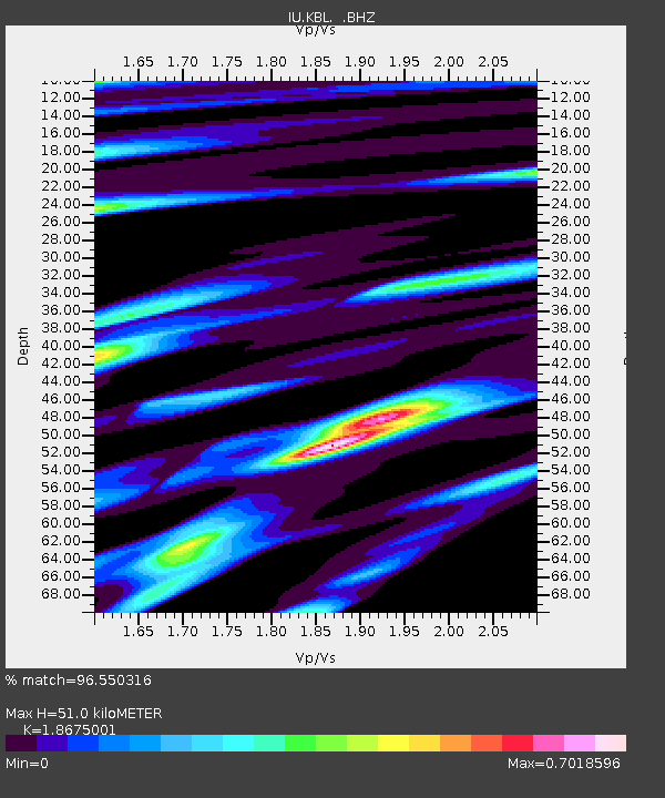
| Estimated Moho Depth: |
51.0 km |
| Estimated Crust Vp/Vs: |
1.87 |
| Assumed Crust Vp: |
6.641 km/s |
| Estimated Crust Vs: |
3.556 km/s |
| Estimated Crust Poisson's Ratio: |
0.30 |
|
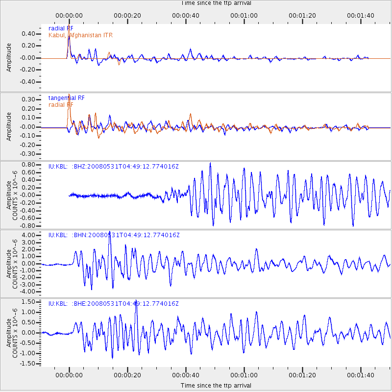
| Radial Match: |
96.550316 % |
| Radial Bump: |
400 |
| Transverse Match: |
92.713196 % |
| Transverse Bump: |
400 |
| SOD ConfigId: |
2504 |
| Insert Time: |
2010-03-03 16:29:11.039 +0000 |
| GWidth: |
2.5 |
| Max Bumps: |
400 |
| Tol: |
0.001 |
|
Signal To Noise
| Channel | StoN | STA | LTA |
| IU:KBL: :BHN:20080531T04:49:12.774016Z | 22.143267 | 9.334721E-7 | 4.2156024E-8 |
| IU:KBL: :BHE:20080531T04:49:12.774016Z | 8.248991 | 2.8556684E-7 | 3.4618395E-8 |
| IU:KBL: :BHZ:20080531T04:49:12.774016Z | 2.6240056 | 7.493511E-8 | 2.8557526E-8 |
| Arrivals |
| Ps | 6.9 SECOND |
| PpPs | 21 SECOND |
| PsPs/PpSs | 28 SECOND |


