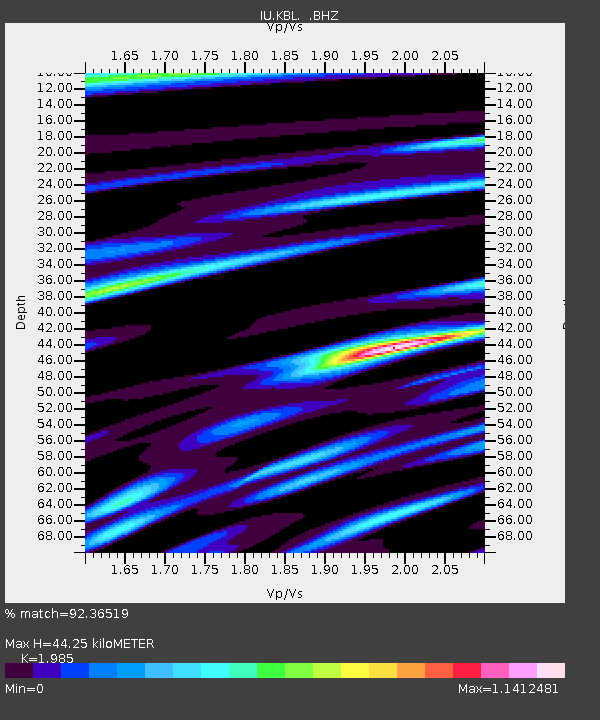
KBL Kabul, Afghanistan - Earthquake Result Viewer
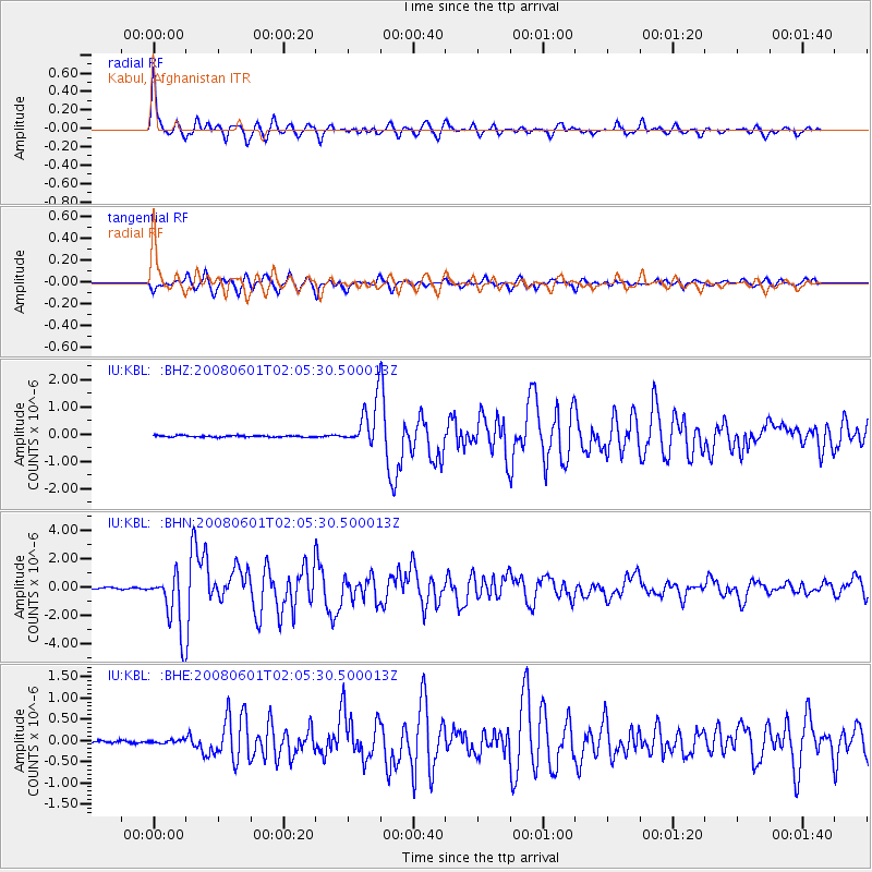
Earthquake location: Philippine Islands Region
Earthquake latitude/longitude: 20.1/121.4
Earthquake time(UTC): 2008/06/01 (153) 01:57:24 GMT
Earthquake Depth: 35 km
Earthquake Magnitude: 6.0 MB, 6.2 MS, 6.3 MW, 6.2 MW
Earthquake Catalog/Contributor: WHDF/NEIC
Network: IU Global Seismograph Network (GSN - IRIS/USGS)
Station: KBL Kabul, Afghanistan
Lat/Lon: 34.54 N/69.04 E
Elevation: 1920 m
Distance: 48.2 deg
Az: 298.704 deg
Baz: 93.213 deg
Ray Param: 0.069473095
Estimated Moho Depth: 44.25 km
Estimated Crust Vp/Vs: 1.99
Assumed Crust Vp: 6.641 km/s
Estimated Crust Vs: 3.345 km/s
Estimated Crust Poisson's Ratio: 0.33
Radial Match: 92.36519 %
Radial Bump: 400
Transverse Match: 82.62333 %
Transverse Bump: 400
SOD ConfigId: 2504
Insert Time: 2010-03-03 16:29:12.853 +0000
GWidth: 2.5
Max Bumps: 400
Tol: 0.001

Signal To Noise

ChannelStoNSTALTA
IU:KBL: :BHN:20080601T02:05:30.500013Z42.428572.0916052E-64.9297096E-8
IU:KBL: :BHE:20080601T02:05:30.500013Z1.6743973.9429256E-82.3548333E-8
IU:KBL: :BHZ:20080601T02:05:30.500013Z26.88338.0912884E-73.0097823E-8
Arrivals
Ps7.0 SECOND
PpPs19 SECOND
PsPs/PpSs26 SECOND