You are here: Home > Network List > UW - Pacific Northwest Regional Seismic Network Stations List
> Station LEBA Lebam, WA, USA > Earthquake Result Viewer
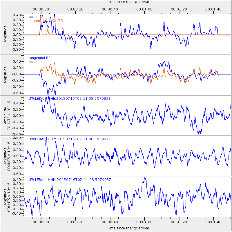
LEBA Lebam, WA, USA - Earthquake Result Viewer
*The percent match for this event was below the threshold and hence no stack was calculated.
| Earthquake location: |
Kermadec Islands Region |
| Earthquake latitude/longitude: |
-27.0/-176.2 |
| Earthquake time(UTC): |
2015/07/16 (197) 01:58:53 GMT |
| Earthquake Depth: |
10 km |
| Earthquake Magnitude: |
5.3 MW |
| Earthquake Catalog/Contributor: |
ISC/ISC |
|
| Network: |
UW Pacific Northwest Regional Seismic Network |
| Station: |
LEBA Lebam, WA, USA |
| Lat/Lon: |
46.55 N/123.56 W |
| Elevation: |
73 m |
|
| Distance: |
87.3 deg |
| Az: |
33.291 deg |
| Baz: |
225.19 deg |
| Ray Param: |
$rayparam |
*The percent match for this event was below the threshold and hence was not used in the summary stack. |
|
| Radial Match: |
41.426933 % |
| Radial Bump: |
400 |
| Transverse Match: |
35.88097 % |
| Transverse Bump: |
400 |
| SOD ConfigId: |
7422571 |
| Insert Time: |
2019-04-19 19:47:55.358 +0000 |
| GWidth: |
2.5 |
| Max Bumps: |
400 |
| Tol: |
0.001 |
|
Signal To Noise
| Channel | StoN | STA | LTA |
| UW:LEBA: :HHZ:20150716T02:11:08.507993Z | 3.4158063 | 2.9857074E-7 | 8.740857E-8 |
| UW:LEBA: :HHN:20150716T02:11:08.507993Z | 1.1097401 | 2.271377E-7 | 2.0467648E-7 |
| UW:LEBA: :HHE:20150716T02:11:08.507993Z | 0.3969141 | 1.01849665E-7 | 2.5660378E-7 |
| Arrivals |
| Ps | |
| PpPs | |
| PsPs/PpSs | |


