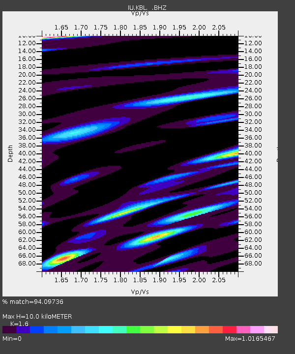
KBL Kabul, Afghanistan - Earthquake Result Viewer
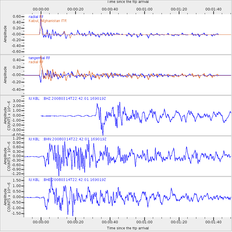
Earthquake location: Bonin Islands, Japan Region
Earthquake latitude/longitude: 27.0/142.6
Earthquake time(UTC): 2008/03/14 (074) 22:32:09 GMT
Earthquake Depth: 11 km
Earthquake Magnitude: 5.7 MB, 5.9 MS, 6.0 MW, 6.0 MW
Earthquake Catalog/Contributor: WHDF/NEIC
Network: IU Global Seismograph Network (GSN - IRIS/USGS)
Station: KBL Kabul, Afghanistan
Lat/Lon: 34.54 N/69.04 E
Elevation: 1920 m
Distance: 62.4 deg
Az: 296.698 deg
Baz: 74.956 deg
Ray Param: 0.060249012
Estimated Moho Depth: 10.0 km
Estimated Crust Vp/Vs: 1.60
Assumed Crust Vp: 6.641 km/s
Estimated Crust Vs: 4.15 km/s
Estimated Crust Poisson's Ratio: 0.18
Radial Match: 94.09736 %
Radial Bump: 400
Transverse Match: 85.62549 %
Transverse Bump: 400
SOD ConfigId: 2564
Insert Time: 2010-03-03 16:29:56.388 +0000
GWidth: 2.5
Max Bumps: 400
Tol: 0.001

Signal To Noise

ChannelStoNSTALTA
IU:KBL: :BHN:20080314T22:42:01.169019Z6.1998962.6196273E-74.2252765E-8
IU:KBL: :BHE:20080314T22:42:01.169019Z18.1670514.5474152E-72.5031113E-8
IU:KBL: :BHZ:20080314T22:42:01.169019Z19.6048951.0454559E-65.3326264E-8
Arrivals
Ps1.0 SECOND
PpPs3.7 SECOND
PsPs/PpSs4.7 SECOND