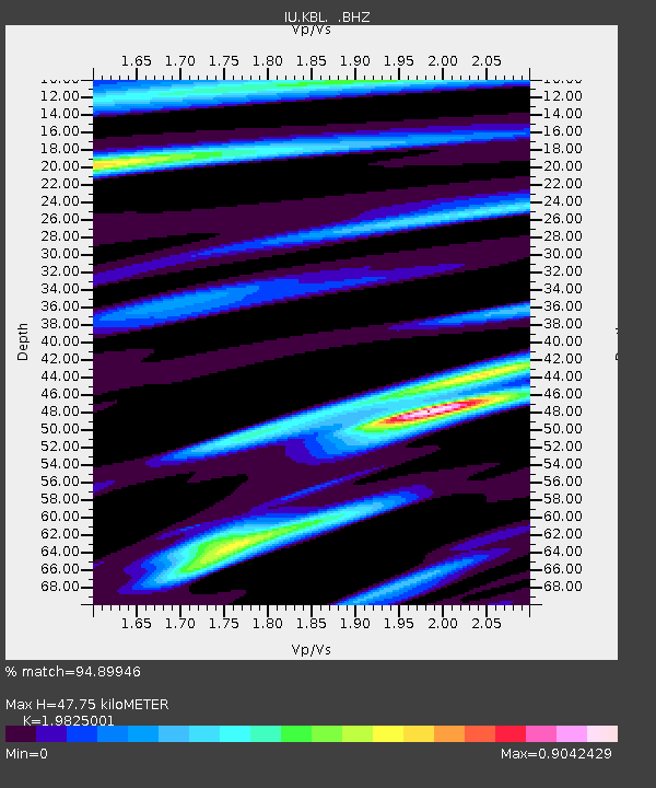
KBL Kabul, Afghanistan - Earthquake Result Viewer
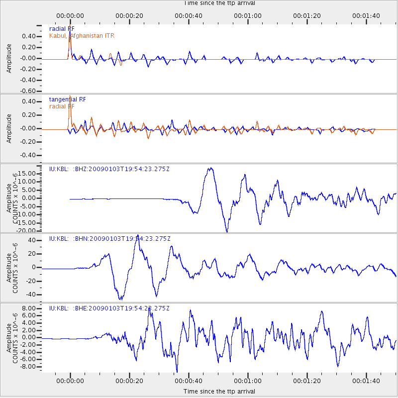
Earthquake location: Irian Jaya Region, Indonesia
Earthquake latitude/longitude: -0.4/132.9
Earthquake time(UTC): 2009/01/03 (003) 19:43:50 GMT
Earthquake Depth: 17 km
Earthquake Magnitude: 6.6 MB, 7.5 MS, 7.6 MW, 7.6 MW
Earthquake Catalog/Contributor: WHDF/NEIC
Network: IU Global Seismograph Network (GSN - IRIS/USGS)
Station: KBL Kabul, Afghanistan
Lat/Lon: 34.54 N/69.04 E
Elevation: 1920 m
Distance: 68.9 deg
Az: 307.425 deg
Baz: 105.845 deg
Ray Param: 0.055981886
Estimated Moho Depth: 47.75 km
Estimated Crust Vp/Vs: 1.98
Assumed Crust Vp: 6.641 km/s
Estimated Crust Vs: 3.35 km/s
Estimated Crust Poisson's Ratio: 0.33
Radial Match: 94.89946 %
Radial Bump: 400
Transverse Match: 91.07178 %
Transverse Bump: 400
SOD ConfigId: 2834
Insert Time: 2010-03-03 16:30:28.827 +0000
GWidth: 2.5
Max Bumps: 400
Tol: 0.001

Signal To Noise

ChannelStoNSTALTA
IU:KBL: :BHN:20090103T19:54:23.275Z4.28904065.959983E-71.3895843E-7
IU:KBL: :BHE:20090103T19:54:23.275Z1.93973965.2969238E-82.7307397E-8
IU:KBL: :BHZ:20090103T19:54:23.275Z3.14734222.1232086E-76.746036E-8
Arrivals
Ps7.3 SECOND
PpPs21 SECOND
PsPs/PpSs28 SECOND