You are here: Home > Network List > AV - Alaska Volcano Observatory Stations List
> Station SPCR Ckakachatna River, Mount Spurr, Alaska > Earthquake Result Viewer
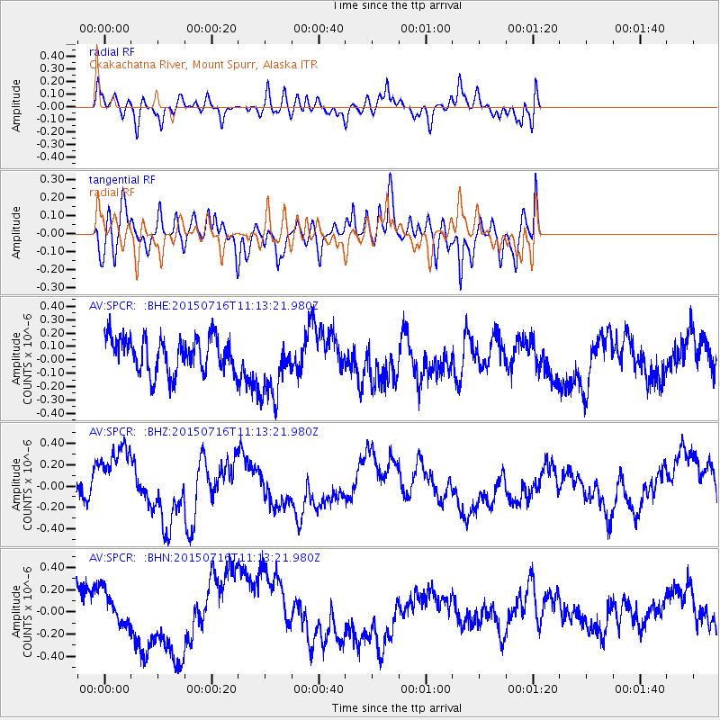
SPCR Ckakachatna River, Mount Spurr, Alaska - Earthquake Result Viewer
*The percent match for this event was below the threshold and hence no stack was calculated.
| Earthquake location: |
North Atlantic Ocean |
| Earthquake latitude/longitude: |
13.9/-58.5 |
| Earthquake time(UTC): |
2015/07/16 (197) 11:01:47 GMT |
| Earthquake Depth: |
13 km |
| Earthquake Magnitude: |
5.7 MWW, 5.6 MWB, 5.7 MWC |
| Earthquake Catalog/Contributor: |
NEIC PDE/NEIC COMCAT |
|
| Network: |
AV Alaska Volcano Observatory |
| Station: |
SPCR Ckakachatna River, Mount Spurr, Alaska |
| Lat/Lon: |
61.20 N/152.21 W |
| Elevation: |
984 m |
|
| Distance: |
79.7 deg |
| Az: |
330.588 deg |
| Baz: |
80.017 deg |
| Ray Param: |
$rayparam |
*The percent match for this event was below the threshold and hence was not used in the summary stack. |
|
| Radial Match: |
56.638462 % |
| Radial Bump: |
400 |
| Transverse Match: |
50.31143 % |
| Transverse Bump: |
400 |
| SOD ConfigId: |
7422571 |
| Insert Time: |
2019-04-19 19:57:06.670 +0000 |
| GWidth: |
2.5 |
| Max Bumps: |
400 |
| Tol: |
0.001 |
|
Signal To Noise
| Channel | StoN | STA | LTA |
| AV:SPCR: :BHZ:20150716T11:13:21.980Z | 1.5195237 | 3.1223234E-7 | 2.0548039E-7 |
| AV:SPCR: :BHN:20150716T11:13:21.980Z | 1.0023558 | 1.6335412E-7 | 1.6297018E-7 |
| AV:SPCR: :BHE:20150716T11:13:21.980Z | 1.5251598 | 1.9952815E-7 | 1.3082442E-7 |
| Arrivals |
| Ps | |
| PpPs | |
| PsPs/PpSs | |


