You are here: Home > Network List > IU - Global Seismograph Network (GSN - IRIS/USGS) Stations List
> Station KBL Kabul, Afghanistan > Earthquake Result Viewer
KBL Kabul, Afghanistan - Earthquake Result Viewer
| Earthquake location: |
South Of Mariana Islands |
| Earthquake latitude/longitude: |
10.5/145.7 |
| Earthquake time(UTC): |
2007/09/30 (273) 02:08:30 GMT |
| Earthquake Depth: |
14 km |
| Earthquake Magnitude: |
6.4 MB, 7.1 MS, 6.9 MW, 6.9 MW |
| Earthquake Catalog/Contributor: |
WHDF/NEIC |
|
| Network: |
IU Global Seismograph Network (GSN - IRIS/USGS) |
| Station: |
KBL Kabul, Afghanistan |
| Lat/Lon: |
34.54 N/69.04 E |
| Elevation: |
1920 m |
|
| Distance: |
73.2 deg |
| Az: |
302.961 deg |
| Baz: |
88.751 deg |
| Ray Param: |
0.053147346 |
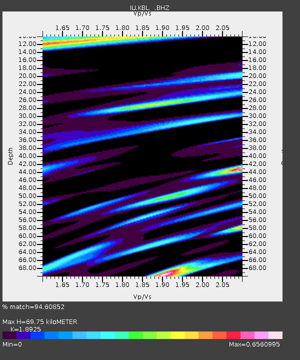
| Estimated Moho Depth: |
69.75 km |
| Estimated Crust Vp/Vs: |
1.89 |
| Assumed Crust Vp: |
6.641 km/s |
| Estimated Crust Vs: |
3.509 km/s |
| Estimated Crust Poisson's Ratio: |
0.31 |
|
| Radial Match: |
94.60852 % |
| Radial Bump: |
400 |
| Transverse Match: |
87.741135 % |
| Transverse Bump: |
400 |
| SOD ConfigId: |
2564 |
| Insert Time: |
2010-03-03 16:31:05.410 +0000 |
| GWidth: |
2.5 |
| Max Bumps: |
400 |
| Tol: |
0.001 |
|
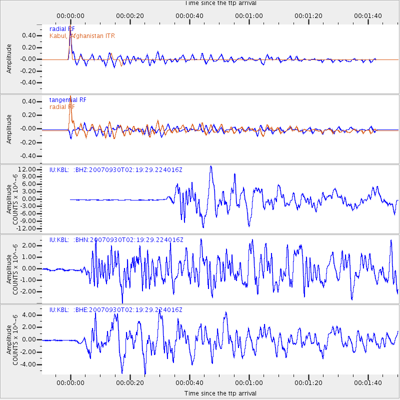
Signal To Noise
| Channel | StoN | STA | LTA |
| IU:KBL: :BHN:20070930T02:19:29.224016Z | 1.8479115 | 8.437757E-8 | 4.5661043E-8 |
| IU:KBL: :BHE:20070930T02:19:29.224016Z | 9.100413 | 2.3230182E-7 | 2.5526514E-8 |
| IU:KBL: :BHZ:20070930T02:19:29.224016Z | 13.699855 | 6.4055473E-7 | 4.6756313E-8 |
| Arrivals |
| Ps | 9.7 SECOND |
| PpPs | 29 SECOND |
| PsPs/PpSs | 39 SECOND |


