You are here: Home > Network List > IU - Global Seismograph Network (GSN - IRIS/USGS) Stations List
> Station KBL Kabul, Afghanistan > Earthquake Result Viewer
KBL Kabul, Afghanistan - Earthquake Result Viewer
| Earthquake location: |
Volcano Islands, Japan Region |
| Earthquake latitude/longitude: |
22.0/142.7 |
| Earthquake time(UTC): |
2007/09/28 (271) 13:38:59 GMT |
| Earthquake Depth: |
276 km |
| Earthquake Magnitude: |
6.7 MB, 7.4 MW, 7.4 MW |
| Earthquake Catalog/Contributor: |
WHDF/NEIC |
|
| Network: |
IU Global Seismograph Network (GSN - IRIS/USGS) |
| Station: |
KBL Kabul, Afghanistan |
| Lat/Lon: |
34.54 N/69.04 E |
| Elevation: |
1920 m |
|
| Distance: |
64.8 deg |
| Az: |
298.891 deg |
| Baz: |
79.831 deg |
| Ray Param: |
0.057848513 |
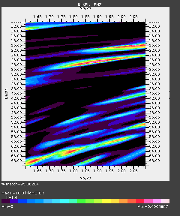
| Estimated Moho Depth: |
10.0 km |
| Estimated Crust Vp/Vs: |
1.60 |
| Assumed Crust Vp: |
6.641 km/s |
| Estimated Crust Vs: |
4.15 km/s |
| Estimated Crust Poisson's Ratio: |
0.18 |
|
| Radial Match: |
95.06284 % |
| Radial Bump: |
400 |
| Transverse Match: |
87.28006 % |
| Transverse Bump: |
400 |
| SOD ConfigId: |
2564 |
| Insert Time: |
2010-03-03 16:31:07.364 +0000 |
| GWidth: |
2.5 |
| Max Bumps: |
400 |
| Tol: |
0.001 |
|
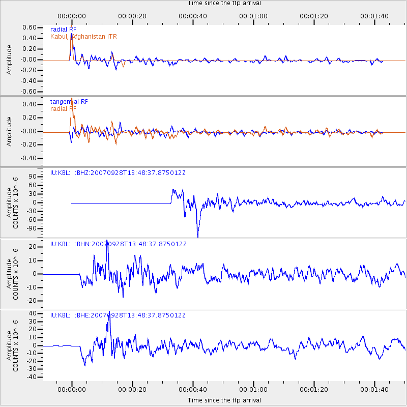
Signal To Noise
| Channel | StoN | STA | LTA |
| IU:KBL: :BHN:20070928T13:48:37.875012Z | 124.11933 | 3.8806957E-6 | 3.126584E-8 |
| IU:KBL: :BHE:20070928T13:48:37.875012Z | 42.114796 | 9.639479E-6 | 2.2888581E-7 |
| IU:KBL: :BHZ:20070928T13:48:37.875012Z | 54.96491 | 2.2348713E-5 | 4.0659964E-7 |
| Arrivals |
| Ps | 0.9 SECOND |
| PpPs | 3.7 SECOND |
| PsPs/PpSs | 4.7 SECOND |


