You are here: Home > Network List > TA - USArray Transportable Network (new EarthScope stations) Stations List
> Station 435B Jarrell, TX, USA > Earthquake Result Viewer
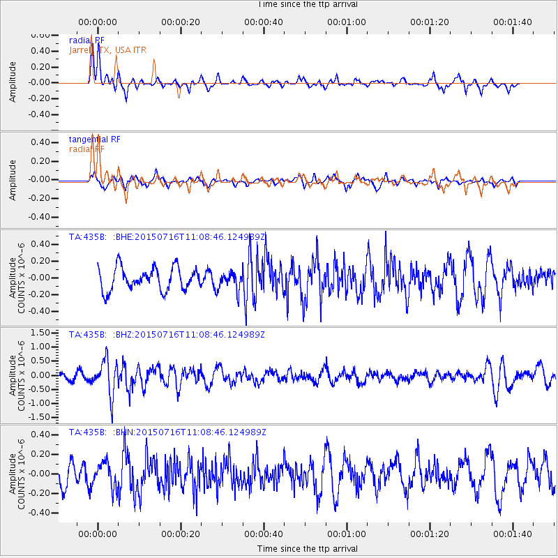
435B Jarrell, TX, USA - Earthquake Result Viewer
*The percent match for this event was below the threshold and hence no stack was calculated.
| Earthquake location: |
North Atlantic Ocean |
| Earthquake latitude/longitude: |
13.9/-58.5 |
| Earthquake time(UTC): |
2015/07/16 (197) 11:01:47 GMT |
| Earthquake Depth: |
13 km |
| Earthquake Magnitude: |
5.7 MWW, 5.6 MWB, 5.7 MWC |
| Earthquake Catalog/Contributor: |
NEIC PDE/NEIC COMCAT |
|
| Network: |
TA USArray Transportable Network (new EarthScope stations) |
| Station: |
435B Jarrell, TX, USA |
| Lat/Lon: |
30.78 N/97.58 W |
| Elevation: |
248 m |
|
| Distance: |
39.6 deg |
| Az: |
301.703 deg |
| Baz: |
106.255 deg |
| Ray Param: |
$rayparam |
*The percent match for this event was below the threshold and hence was not used in the summary stack. |
|
| Radial Match: |
68.62157 % |
| Radial Bump: |
334 |
| Transverse Match: |
57.487804 % |
| Transverse Bump: |
324 |
| SOD ConfigId: |
7422571 |
| Insert Time: |
2019-04-19 20:01:22.600 +0000 |
| GWidth: |
2.5 |
| Max Bumps: |
400 |
| Tol: |
0.001 |
|
Signal To Noise
| Channel | StoN | STA | LTA |
| TA:435B: :BHZ:20150716T11:08:46.124989Z | 6.7265854 | 6.314168E-7 | 9.386884E-8 |
| TA:435B: :BHN:20150716T11:08:46.124989Z | 0.9823395 | 1.3088359E-7 | 1.3323663E-7 |
| TA:435B: :BHE:20150716T11:08:46.124989Z | 1.3195359 | 1.7345258E-7 | 1.314497E-7 |
| Arrivals |
| Ps | |
| PpPs | |
| PsPs/PpSs | |


