You are here: Home > Network List > TA - USArray Transportable Network (new EarthScope stations) Stations List
> Station G65A Princeton, ME, USA > Earthquake Result Viewer
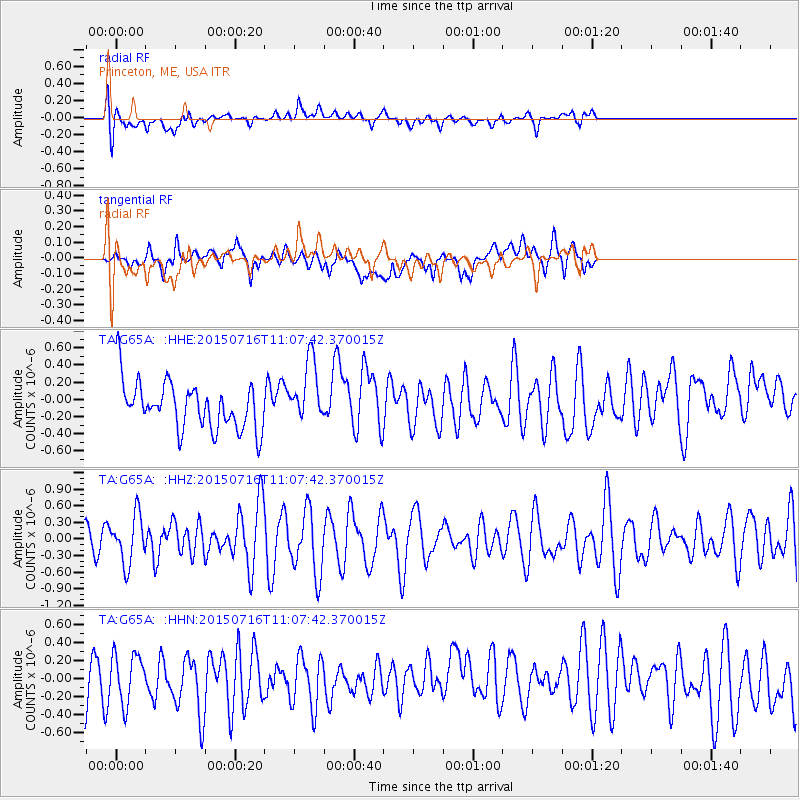
G65A Princeton, ME, USA - Earthquake Result Viewer
*The percent match for this event was below the threshold and hence no stack was calculated.
| Earthquake location: |
North Atlantic Ocean |
| Earthquake latitude/longitude: |
13.9/-58.5 |
| Earthquake time(UTC): |
2015/07/16 (197) 11:01:47 GMT |
| Earthquake Depth: |
13 km |
| Earthquake Magnitude: |
5.7 MWW, 5.6 MWB, 5.7 MWC |
| Earthquake Catalog/Contributor: |
NEIC PDE/NEIC COMCAT |
|
| Network: |
TA USArray Transportable Network (new EarthScope stations) |
| Station: |
G65A Princeton, ME, USA |
| Lat/Lon: |
45.20 N/67.56 W |
| Elevation: |
78 m |
|
| Distance: |
32.1 deg |
| Az: |
347.909 deg |
| Baz: |
163.278 deg |
| Ray Param: |
$rayparam |
*The percent match for this event was below the threshold and hence was not used in the summary stack. |
|
| Radial Match: |
64.52859 % |
| Radial Bump: |
400 |
| Transverse Match: |
47.230152 % |
| Transverse Bump: |
400 |
| SOD ConfigId: |
7422571 |
| Insert Time: |
2019-04-19 20:01:30.135 +0000 |
| GWidth: |
2.5 |
| Max Bumps: |
400 |
| Tol: |
0.001 |
|
Signal To Noise
| Channel | StoN | STA | LTA |
| TA:G65A: :HHZ:20150716T11:07:42.370015Z | 1.2960926 | 4.3296754E-7 | 3.34056E-7 |
| TA:G65A: :HHN:20150716T11:07:42.370015Z | 0.98180926 | 2.654139E-7 | 2.703314E-7 |
| TA:G65A: :HHE:20150716T11:07:42.370015Z | 1.6012093 | 3.7418295E-7 | 2.3368771E-7 |
| Arrivals |
| Ps | |
| PpPs | |
| PsPs/PpSs | |


