You are here: Home > Network List > TA - USArray Transportable Network (new EarthScope stations) Stations List
> Station Z41A Richland Creek Farm, El Dorado, AR, USA > Earthquake Result Viewer
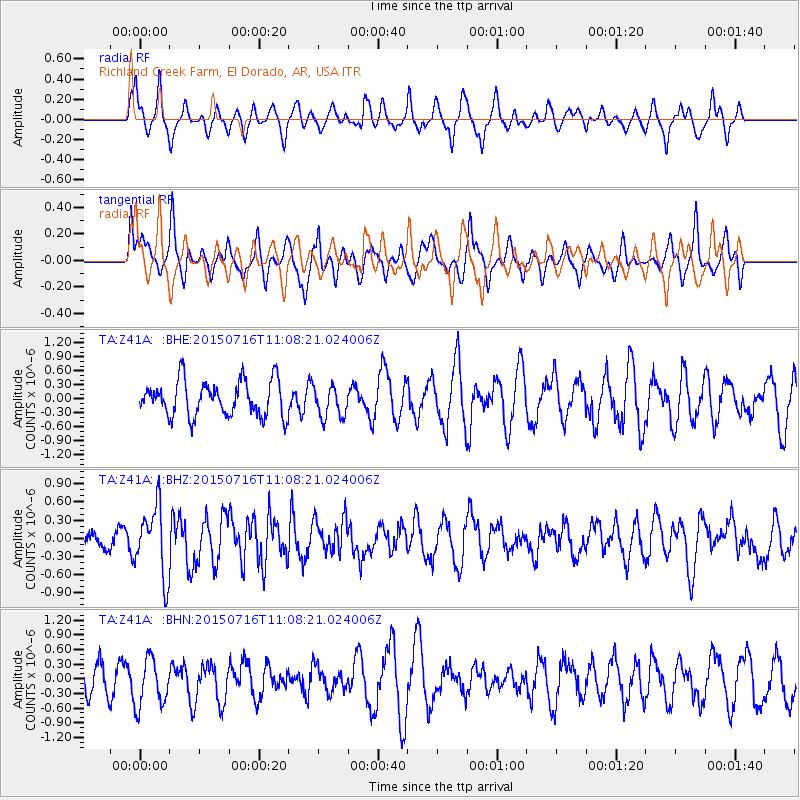
Z41A Richland Creek Farm, El Dorado, AR, USA - Earthquake Result Viewer
*The percent match for this event was below the threshold and hence no stack was calculated.
| Earthquake location: |
North Atlantic Ocean |
| Earthquake latitude/longitude: |
13.9/-58.5 |
| Earthquake time(UTC): |
2015/07/16 (197) 11:01:47 GMT |
| Earthquake Depth: |
13 km |
| Earthquake Magnitude: |
5.7 MWW, 5.6 MWB, 5.7 MWC |
| Earthquake Catalog/Contributor: |
NEIC PDE/NEIC COMCAT |
|
| Network: |
TA USArray Transportable Network (new EarthScope stations) |
| Station: |
Z41A Richland Creek Farm, El Dorado, AR, USA |
| Lat/Lon: |
33.26 N/92.80 W |
| Elevation: |
62 m |
|
| Distance: |
36.6 deg |
| Az: |
307.696 deg |
| Baz: |
113.496 deg |
| Ray Param: |
$rayparam |
*The percent match for this event was below the threshold and hence was not used in the summary stack. |
|
| Radial Match: |
75.02628 % |
| Radial Bump: |
360 |
| Transverse Match: |
66.32734 % |
| Transverse Bump: |
400 |
| SOD ConfigId: |
7422571 |
| Insert Time: |
2019-04-19 20:01:50.685 +0000 |
| GWidth: |
2.5 |
| Max Bumps: |
400 |
| Tol: |
0.001 |
|
Signal To Noise
| Channel | StoN | STA | LTA |
| TA:Z41A: :BHZ:20150716T11:08:21.024006Z | 2.740055 | 5.706929E-7 | 2.082779E-7 |
| TA:Z41A: :BHN:20150716T11:08:21.024006Z | 1.6066395 | 4.864209E-7 | 3.0275672E-7 |
| TA:Z41A: :BHE:20150716T11:08:21.024006Z | 0.90169805 | 3.3828084E-7 | 3.7515977E-7 |
| Arrivals |
| Ps | |
| PpPs | |
| PsPs/PpSs | |


