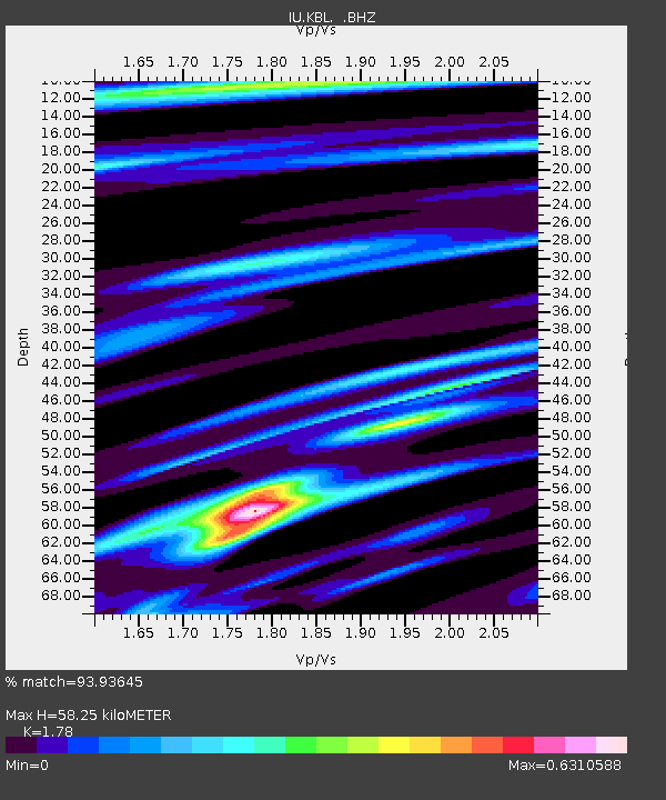
KBL Kabul, Afghanistan - Earthquake Result Viewer
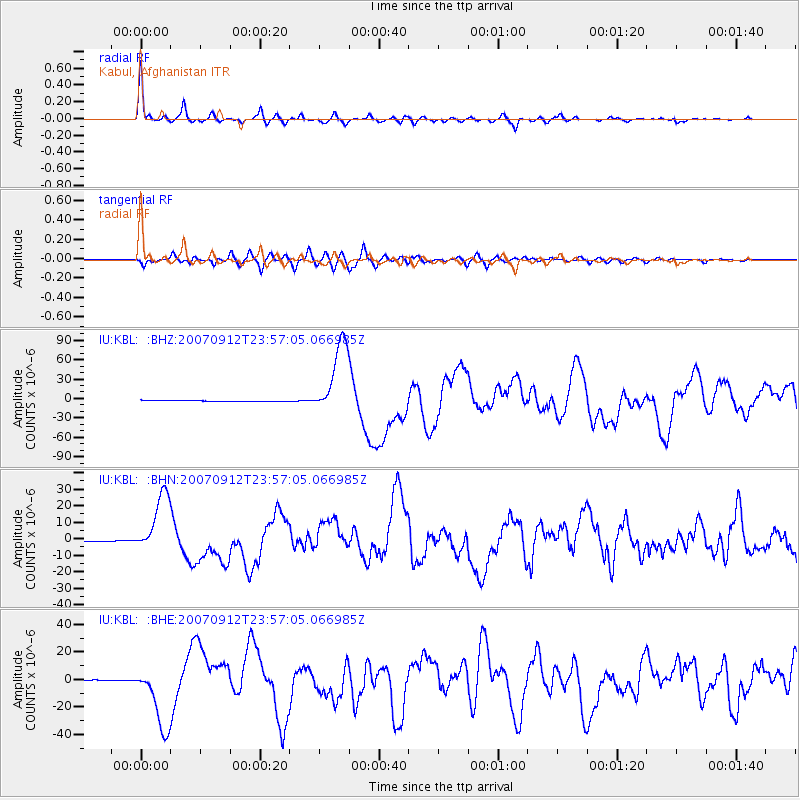
Earthquake location: Southern Sumatra, Indonesia
Earthquake latitude/longitude: -2.6/100.8
Earthquake time(UTC): 2007/09/12 (255) 23:49:03 GMT
Earthquake Depth: 35 km
Earthquake Magnitude: 6.6 MB, 8.1 MS, 7.9 MW, 7.6 ME
Earthquake Catalog/Contributor: WHDF/NEIC
Network: IU Global Seismograph Network (GSN - IRIS/USGS)
Station: KBL Kabul, Afghanistan
Lat/Lon: 34.54 N/69.04 E
Elevation: 1920 m
Distance: 47.5 deg
Az: 323.866 deg
Baz: 134.472 deg
Ray Param: 0.06985999
Estimated Moho Depth: 58.25 km
Estimated Crust Vp/Vs: 1.78
Assumed Crust Vp: 6.641 km/s
Estimated Crust Vs: 3.731 km/s
Estimated Crust Poisson's Ratio: 0.27
Radial Match: 93.93645 %
Radial Bump: 363
Transverse Match: 87.688156 %
Transverse Bump: 400
SOD ConfigId: 2564
Insert Time: 2010-03-03 16:31:26.510 +0000
GWidth: 2.5
Max Bumps: 400
Tol: 0.001

Signal To Noise

ChannelStoNSTALTA
IU:KBL: :BHN:20070912T23:57:05.066985Z58.0151371.8410841E-53.1734547E-7
IU:KBL: :BHE:20070912T23:57:05.066985Z56.9793132.3562985E-54.135358E-7
IU:KBL: :BHZ:20070912T23:57:05.066985Z81.952215.8351743E-57.120216E-7
Arrivals
Ps7.3 SECOND
PpPs23 SECOND
PsPs/PpSs30 SECOND