You are here: Home > Network List > IU - Global Seismograph Network (GSN - IRIS/USGS) Stations List
> Station POHA Pohakuloa, Hawaii, USA > Earthquake Result Viewer
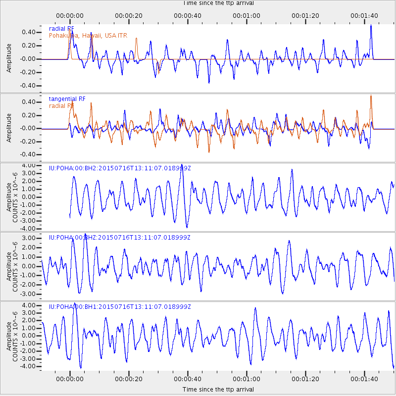
POHA Pohakuloa, Hawaii, USA - Earthquake Result Viewer
*The percent match for this event was below the threshold and hence no stack was calculated.
| Earthquake location: |
Mariana Islands |
| Earthquake latitude/longitude: |
14.6/146.9 |
| Earthquake time(UTC): |
2015/07/16 (197) 13:02:06 GMT |
| Earthquake Depth: |
10 km |
| Earthquake Magnitude: |
5.0 MW |
| Earthquake Catalog/Contributor: |
ISC/ISC |
|
| Network: |
IU Global Seismograph Network (GSN - IRIS/USGS) |
| Station: |
POHA Pohakuloa, Hawaii, USA |
| Lat/Lon: |
19.76 N/155.53 W |
| Elevation: |
1990 m |
|
| Distance: |
55.0 deg |
| Az: |
75.988 deg |
| Baz: |
274.337 deg |
| Ray Param: |
$rayparam |
*The percent match for this event was below the threshold and hence was not used in the summary stack. |
|
| Radial Match: |
61.08948 % |
| Radial Bump: |
400 |
| Transverse Match: |
42.286427 % |
| Transverse Bump: |
388 |
| SOD ConfigId: |
7422571 |
| Insert Time: |
2019-04-19 20:06:00.520 +0000 |
| GWidth: |
2.5 |
| Max Bumps: |
400 |
| Tol: |
0.001 |
|
Signal To Noise
| Channel | StoN | STA | LTA |
| IU:POHA:00:BHZ:20150716T13:11:07.018999Z | 2.27495 | 1.9733557E-6 | 8.674281E-7 |
| IU:POHA:00:BH1:20150716T13:11:07.018999Z | 2.4057941 | 2.7981453E-6 | 1.1630859E-6 |
| IU:POHA:00:BH2:20150716T13:11:07.018999Z | 0.9864791 | 1.3289408E-6 | 1.3471556E-6 |
| Arrivals |
| Ps | |
| PpPs | |
| PsPs/PpSs | |


