You are here: Home > Network List > TA - USArray Transportable Network (new EarthScope stations) Stations List
> Station J01E Myrtle Point, OR, USA > Earthquake Result Viewer
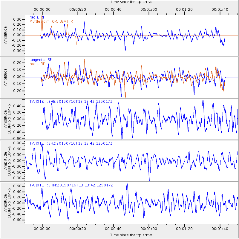
J01E Myrtle Point, OR, USA - Earthquake Result Viewer
*The percent match for this event was below the threshold and hence no stack was calculated.
| Earthquake location: |
Mariana Islands |
| Earthquake latitude/longitude: |
14.6/146.9 |
| Earthquake time(UTC): |
2015/07/16 (197) 13:02:06 GMT |
| Earthquake Depth: |
10 km |
| Earthquake Magnitude: |
5.0 MW |
| Earthquake Catalog/Contributor: |
ISC/ISC |
|
| Network: |
TA USArray Transportable Network (new EarthScope stations) |
| Station: |
J01E Myrtle Point, OR, USA |
| Lat/Lon: |
43.16 N/123.93 W |
| Elevation: |
128 m |
|
| Distance: |
79.5 deg |
| Az: |
48.076 deg |
| Baz: |
280.184 deg |
| Ray Param: |
$rayparam |
*The percent match for this event was below the threshold and hence was not used in the summary stack. |
|
| Radial Match: |
53.04613 % |
| Radial Bump: |
400 |
| Transverse Match: |
55.35328 % |
| Transverse Bump: |
400 |
| SOD ConfigId: |
7422571 |
| Insert Time: |
2019-04-19 20:07:24.467 +0000 |
| GWidth: |
2.5 |
| Max Bumps: |
400 |
| Tol: |
0.001 |
|
Signal To Noise
| Channel | StoN | STA | LTA |
| TA:J01E: :BHZ:20150716T13:13:42.125017Z | 2.4644485 | 5.339026E-7 | 2.1664184E-7 |
| TA:J01E: :BHN:20150716T13:13:42.125017Z | 1.3419493 | 2.60567E-7 | 1.9417051E-7 |
| TA:J01E: :BHE:20150716T13:13:42.125017Z | 1.0730902 | 2.0260529E-7 | 1.8880546E-7 |
| Arrivals |
| Ps | |
| PpPs | |
| PsPs/PpSs | |


