You are here: Home > Network List > US - United States National Seismic Network Stations List
> Station DGMT Dagmar, Montana, USA > Earthquake Result Viewer
DGMT Dagmar, Montana, USA - Earthquake Result Viewer
*The percent match for this event was below the threshold and hence no stack was calculated.
| Earthquake location: |
Mariana Islands |
| Earthquake latitude/longitude: |
14.6/146.9 |
| Earthquake time(UTC): |
2015/07/16 (197) 13:02:06 GMT |
| Earthquake Depth: |
10 km |
| Earthquake Magnitude: |
5.0 MW |
| Earthquake Catalog/Contributor: |
ISC/ISC |
|
| Network: |
US United States National Seismic Network |
| Station: |
DGMT Dagmar, Montana, USA |
| Lat/Lon: |
48.47 N/104.20 W |
| Elevation: |
0.0 m |
|
| Distance: |
91.2 deg |
| Az: |
39.039 deg |
| Baz: |
293.639 deg |
| Ray Param: |
$rayparam |
*The percent match for this event was below the threshold and hence was not used in the summary stack. |
|
| Radial Match: |
62.77727 % |
| Radial Bump: |
400 |
| Transverse Match: |
67.96767 % |
| Transverse Bump: |
303 |
| SOD ConfigId: |
7422571 |
| Insert Time: |
2019-04-19 20:07:48.544 +0000 |
| GWidth: |
2.5 |
| Max Bumps: |
400 |
| Tol: |
0.001 |
|
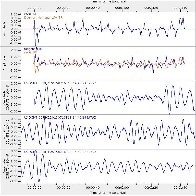
Signal To Noise
| Channel | StoN | STA | LTA |
| US:DGMT:00:BHZ:20150716T13:14:40.248979Z | 1.4679745 | 3.4428453E-7 | 2.3453033E-7 |
| US:DGMT:00:BH1:20150716T13:14:40.248979Z | 1.5545574 | 2.1516028E-6 | 1.3840613E-6 |
| US:DGMT:00:BH2:20150716T13:14:40.248979Z | 0.98771435 | 1.0107514E-6 | 1.0233235E-6 |
| Arrivals |
| Ps | |
| PpPs | |
| PsPs/PpSs | |


