You are here: Home > Network List > US - United States National Seismic Network Stations List
> Station MSO Missoula, Montana, USA > Earthquake Result Viewer
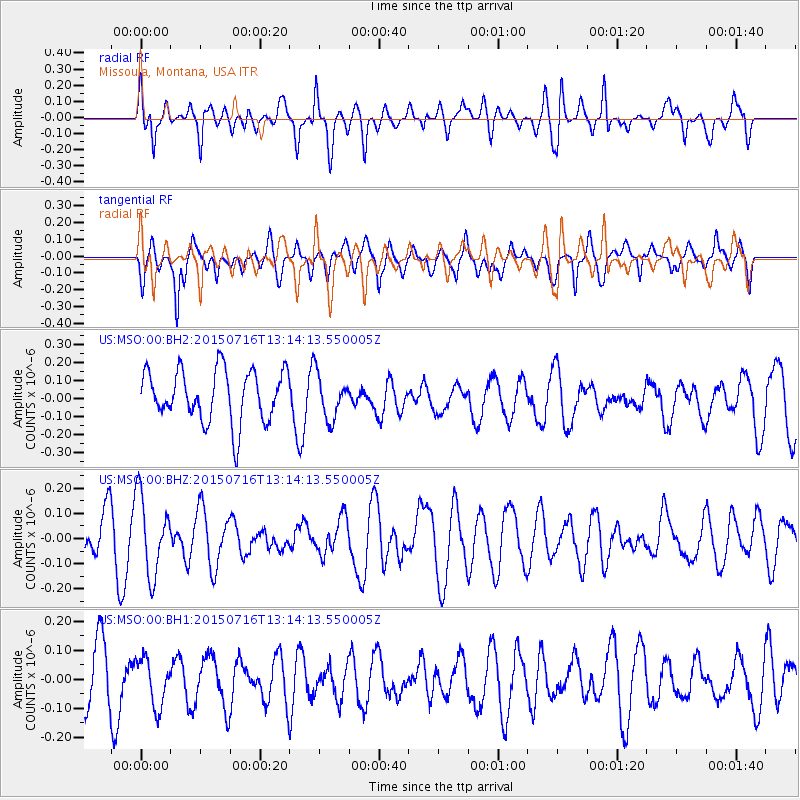
MSO Missoula, Montana, USA - Earthquake Result Viewer
*The percent match for this event was below the threshold and hence no stack was calculated.
| Earthquake location: |
Mariana Islands |
| Earthquake latitude/longitude: |
14.6/146.9 |
| Earthquake time(UTC): |
2015/07/16 (197) 13:02:06 GMT |
| Earthquake Depth: |
10 km |
| Earthquake Magnitude: |
5.0 MW |
| Earthquake Catalog/Contributor: |
ISC/ISC |
|
| Network: |
US United States National Seismic Network |
| Station: |
MSO Missoula, Montana, USA |
| Lat/Lon: |
46.83 N/113.94 W |
| Elevation: |
1264 m |
|
| Distance: |
85.6 deg |
| Az: |
42.839 deg |
| Baz: |
286.557 deg |
| Ray Param: |
$rayparam |
*The percent match for this event was below the threshold and hence was not used in the summary stack. |
|
| Radial Match: |
57.906326 % |
| Radial Bump: |
400 |
| Transverse Match: |
60.418346 % |
| Transverse Bump: |
400 |
| SOD ConfigId: |
7422571 |
| Insert Time: |
2019-04-19 20:07:51.003 +0000 |
| GWidth: |
2.5 |
| Max Bumps: |
400 |
| Tol: |
0.001 |
|
Signal To Noise
| Channel | StoN | STA | LTA |
| US:MSO:00:BHZ:20150716T13:14:13.550005Z | 1.5539383 | 1.5397661E-7 | 9.9087984E-8 |
| US:MSO:00:BH1:20150716T13:14:13.550005Z | 0.70825636 | 8.433272E-8 | 1.190709E-7 |
| US:MSO:00:BH2:20150716T13:14:13.550005Z | 0.8595447 | 1.2275954E-7 | 1.4281927E-7 |
| Arrivals |
| Ps | |
| PpPs | |
| PsPs/PpSs | |


