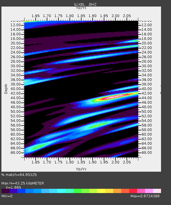
KBL Kabul, Afghanistan - Earthquake Result Viewer
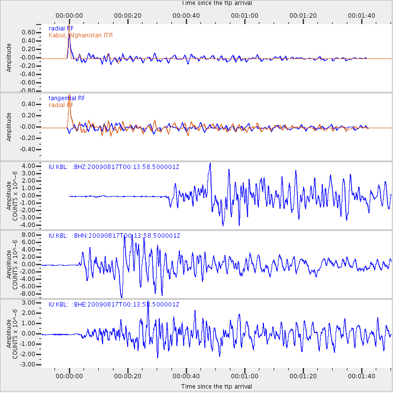
Earthquake location: Southwestern Ryukyu Isl., Japan
Earthquake latitude/longitude: 23.5/123.5
Earthquake time(UTC): 2009/08/17 (229) 00:05:49 GMT
Earthquake Depth: 20 km
Earthquake Magnitude: 6.2 MB, 6.6 MS, 6.7 MW, 6.6 MW
Earthquake Catalog/Contributor: WHDF/NEIC
Network: IU Global Seismograph Network (GSN - IRIS/USGS)
Station: KBL Kabul, Afghanistan
Lat/Lon: 34.54 N/69.04 E
Elevation: 1920 m
Distance: 48.4 deg
Az: 296.018 deg
Baz: 87.998 deg
Ray Param: 0.06938259
Estimated Moho Depth: 43.25 km
Estimated Crust Vp/Vs: 2.00
Assumed Crust Vp: 6.641 km/s
Estimated Crust Vs: 3.329 km/s
Estimated Crust Poisson's Ratio: 0.33
Radial Match: 94.95325 %
Radial Bump: 400
Transverse Match: 89.284966 %
Transverse Bump: 400
SOD ConfigId: 2622
Insert Time: 2010-03-03 16:32:26.401 +0000
GWidth: 2.5
Max Bumps: 400
Tol: 0.001

Signal To Noise

ChannelStoNSTALTA
IU:KBL: :BHN:20090817T00:13:58.500001Z16.7062991.0140855E-66.0700785E-8
IU:KBL: :BHE:20090817T00:13:58.500001Z3.47090489.74854E-82.808645E-8
IU:KBL: :BHZ:20090817T00:13:58.500001Z11.9997034.2617611E-73.5515555E-8
Arrivals
Ps6.9 SECOND
PpPs18 SECOND
PsPs/PpSs25 SECOND