You are here: Home > Network List > 7A - Mid-Atlantic Geophysical Integrative Collaboration Stations List
> Station CAKE Sugar Grove, West Virginia USA > Earthquake Result Viewer
CAKE Sugar Grove, West Virginia USA - Earthquake Result Viewer
| Earthquake location: |
North Atlantic Ocean |
| Earthquake latitude/longitude: |
13.9/-58.5 |
| Earthquake time(UTC): |
2015/07/16 (197) 15:16:32 GMT |
| Earthquake Depth: |
10 km |
| Earthquake Magnitude: |
6.5 MWW, 6.5 MWC, 6.5 MWB, 6.5 MI |
| Earthquake Catalog/Contributor: |
NEIC PDE/NEIC COMCAT |
|
| Network: |
7A Mid-Atlantic Geophysical Integrative Collaboration |
| Station: |
CAKE Sugar Grove, West Virginia USA |
| Lat/Lon: |
38.52 N/79.30 W |
| Elevation: |
640 m |
|
| Distance: |
30.7 deg |
| Az: |
326.992 deg |
| Baz: |
137.584 deg |
| Ray Param: |
0.07926961 |
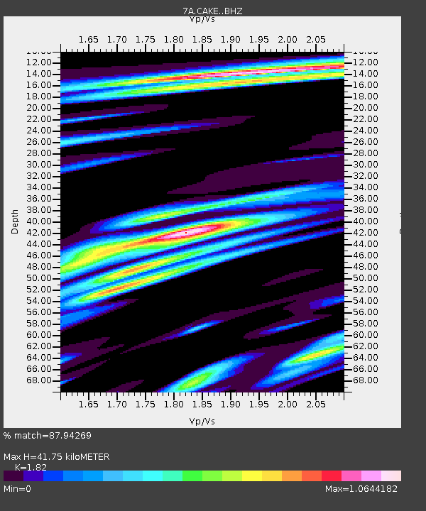
| Estimated Moho Depth: |
41.75 km |
| Estimated Crust Vp/Vs: |
1.82 |
| Assumed Crust Vp: |
6.159 km/s |
| Estimated Crust Vs: |
3.384 km/s |
| Estimated Crust Poisson's Ratio: |
0.28 |
|
| Radial Match: |
87.94269 % |
| Radial Bump: |
400 |
| Transverse Match: |
57.9449 % |
| Transverse Bump: |
400 |
| SOD ConfigId: |
7422571 |
| Insert Time: |
2019-04-19 20:09:22.586 +0000 |
| GWidth: |
2.5 |
| Max Bumps: |
400 |
| Tol: |
0.001 |
|

Signal To Noise
| Channel | StoN | STA | LTA |
| 7A:CAKE: :BHZ:20150716T15:22:15.985004Z | 1.6995794 | 4.6184292E-7 | 2.7173954E-7 |
| 7A:CAKE: :BHN:20150716T15:22:15.985004Z | 1.5489051 | 3.696908E-7 | 2.3867878E-7 |
| 7A:CAKE: :BHE:20150716T15:22:15.985004Z | 1.0038527 | 2.6205905E-7 | 2.6105326E-7 |
| Arrivals |
| Ps | 6.0 SECOND |
| PpPs | 18 SECOND |
| PsPs/PpSs | 24 SECOND |


