You are here: Home > Network List > 7A - Mid-Atlantic Geophysical Integrative Collaboration Stations List
> Station KENT Kenton, Ohio USA > Earthquake Result Viewer
KENT Kenton, Ohio USA - Earthquake Result Viewer
| Earthquake location: |
North Atlantic Ocean |
| Earthquake latitude/longitude: |
13.9/-58.5 |
| Earthquake time(UTC): |
2015/07/16 (197) 15:16:32 GMT |
| Earthquake Depth: |
10 km |
| Earthquake Magnitude: |
6.5 MWW, 6.5 MWC, 6.5 MWB, 6.5 MI |
| Earthquake Catalog/Contributor: |
NEIC PDE/NEIC COMCAT |
|
| Network: |
7A Mid-Atlantic Geophysical Integrative Collaboration |
| Station: |
KENT Kenton, Ohio USA |
| Lat/Lon: |
40.63 N/83.64 W |
| Elevation: |
296 m |
|
| Distance: |
34.5 deg |
| Az: |
325.295 deg |
| Baz: |
133.402 deg |
| Ray Param: |
0.07769647 |
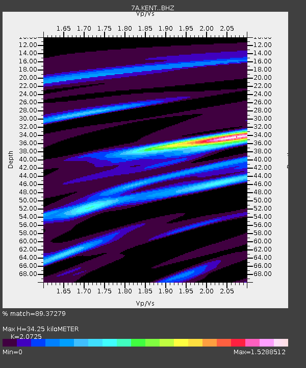
| Estimated Moho Depth: |
34.25 km |
| Estimated Crust Vp/Vs: |
2.07 |
| Assumed Crust Vp: |
6.498 km/s |
| Estimated Crust Vs: |
3.135 km/s |
| Estimated Crust Poisson's Ratio: |
0.35 |
|
| Radial Match: |
89.37279 % |
| Radial Bump: |
348 |
| Transverse Match: |
63.74902 % |
| Transverse Bump: |
400 |
| SOD ConfigId: |
7422571 |
| Insert Time: |
2019-04-19 20:09:26.028 +0000 |
| GWidth: |
2.5 |
| Max Bumps: |
400 |
| Tol: |
0.001 |
|

Signal To Noise
| Channel | StoN | STA | LTA |
| 7A:KENT: :BHZ:20150716T15:22:49.56499Z | 2.1207817 | 3.5514512E-7 | 1.6745955E-7 |
| 7A:KENT: :BHN:20150716T15:22:49.56499Z | 1.3736545 | 2.0634941E-7 | 1.502193E-7 |
| 7A:KENT: :BHE:20150716T15:22:49.56499Z | 1.5881042 | 2.387119E-7 | 1.5031247E-7 |
| Arrivals |
| Ps | 6.0 SECOND |
| PpPs | 15 SECOND |
| PsPs/PpSs | 21 SECOND |


