You are here: Home > Network List > BE - Belgian Seismic Network Stations List
> Station MEM Membach, Belgium > Earthquake Result Viewer
MEM Membach, Belgium - Earthquake Result Viewer
| Earthquake location: |
North Atlantic Ocean |
| Earthquake latitude/longitude: |
13.9/-58.5 |
| Earthquake time(UTC): |
2015/07/16 (197) 15:16:32 GMT |
| Earthquake Depth: |
10 km |
| Earthquake Magnitude: |
6.5 MWW, 6.5 MWC, 6.5 MWB, 6.5 MI |
| Earthquake Catalog/Contributor: |
NEIC PDE/NEIC COMCAT |
|
| Network: |
BE Belgian Seismic Network |
| Station: |
MEM Membach, Belgium |
| Lat/Lon: |
50.61 N/6.01 E |
| Elevation: |
250 m |
|
| Distance: |
63.3 deg |
| Az: |
40.091 deg |
| Baz: |
259.031 deg |
| Ray Param: |
0.059664376 |
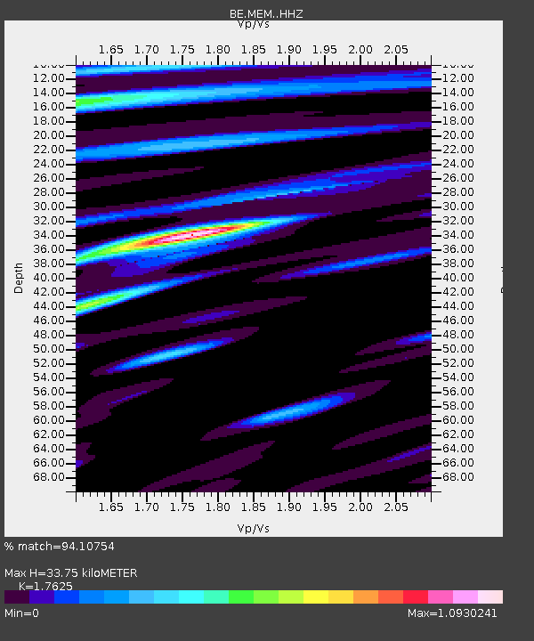
| Estimated Moho Depth: |
33.75 km |
| Estimated Crust Vp/Vs: |
1.76 |
| Assumed Crust Vp: |
6.276 km/s |
| Estimated Crust Vs: |
3.561 km/s |
| Estimated Crust Poisson's Ratio: |
0.26 |
|
| Radial Match: |
94.10754 % |
| Radial Bump: |
400 |
| Transverse Match: |
82.187386 % |
| Transverse Bump: |
400 |
| SOD ConfigId: |
7422571 |
| Insert Time: |
2019-04-19 20:10:57.127 +0000 |
| GWidth: |
2.5 |
| Max Bumps: |
400 |
| Tol: |
0.001 |
|

Signal To Noise
| Channel | StoN | STA | LTA |
| BE:MEM: :HHZ:20150716T15:26:29.718005Z | 11.182162 | 1.243498E-6 | 1.11203725E-7 |
| BE:MEM: :HHN:20150716T15:26:29.718005Z | 1.1745437 | 1.0704535E-7 | 9.1137814E-8 |
| BE:MEM: :HHE:20150716T15:26:29.718005Z | 6.537487 | 6.1124416E-7 | 9.3498336E-8 |
| Arrivals |
| Ps | 4.3 SECOND |
| PpPs | 14 SECOND |
| PsPs/PpSs | 19 SECOND |


