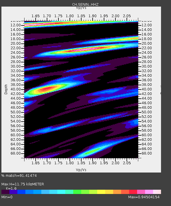
SENIN Lac Selin/Sanetsch - Earthquake Result Viewer

Earthquake location: North Atlantic Ocean
Earthquake latitude/longitude: 13.9/-58.5
Earthquake time(UTC): 2015/07/16 (197) 15:16:32 GMT
Earthquake Depth: 10 km
Earthquake Magnitude: 6.5 MWW, 6.5 MWC, 6.5 MWB, 6.5 MI
Earthquake Catalog/Contributor: NEIC PDE/NEIC COMCAT
Network: CH Switzerland Seismological Network
Station: SENIN Lac Selin/Sanetsch
Lat/Lon: 46.36 N/7.30 E
Elevation: 2035 m
Distance: 63.5 deg
Az: 44.938 deg
Baz: 262.169 deg
Ray Param: 0.0595642
Estimated Moho Depth: 11.75 km
Estimated Crust Vp/Vs: 1.60
Assumed Crust Vp: 6.276 km/s
Estimated Crust Vs: 3.922 km/s
Estimated Crust Poisson's Ratio: 0.18
Radial Match: 91.41474 %
Radial Bump: 400
Transverse Match: 81.32044 %
Transverse Bump: 400
SOD ConfigId: 7422571
Insert Time: 2019-04-19 20:11:41.516 +0000
GWidth: 2.5
Max Bumps: 400
Tol: 0.001

Signal To Noise

ChannelStoNSTALTA
CH:SENIN: :HHZ:20150716T15:26:30.728992Z12.045219.757182E-78.1004664E-8
CH:SENIN: :HHN:20150716T15:26:30.728992Z2.21937081.4868363E-76.699359E-8
CH:SENIN: :HHE:20150716T15:26:30.728992Z6.6371723.8727026E-75.8348682E-8
Arrivals
Ps1.2 SECOND
PpPs4.6 SECOND
PsPs/PpSs5.8 SECOND