You are here: Home > Network List > CI - Caltech Regional Seismic Network Stations List
> Station VES Vestal, Richgrove, CA, USA > Earthquake Result Viewer
VES Vestal, Richgrove, CA, USA - Earthquake Result Viewer
| Earthquake location: |
North Atlantic Ocean |
| Earthquake latitude/longitude: |
13.9/-58.5 |
| Earthquake time(UTC): |
2015/07/16 (197) 15:16:32 GMT |
| Earthquake Depth: |
10 km |
| Earthquake Magnitude: |
6.5 MWW, 6.5 MWC, 6.5 MWB, 6.5 MI |
| Earthquake Catalog/Contributor: |
NEIC PDE/NEIC COMCAT |
|
| Network: |
CI Caltech Regional Seismic Network |
| Station: |
VES Vestal, Richgrove, CA, USA |
| Lat/Lon: |
35.84 N/119.08 W |
| Elevation: |
154 m |
|
| Distance: |
58.2 deg |
| Az: |
303.662 deg |
| Baz: |
95.751 deg |
| Ray Param: |
0.06299743 |
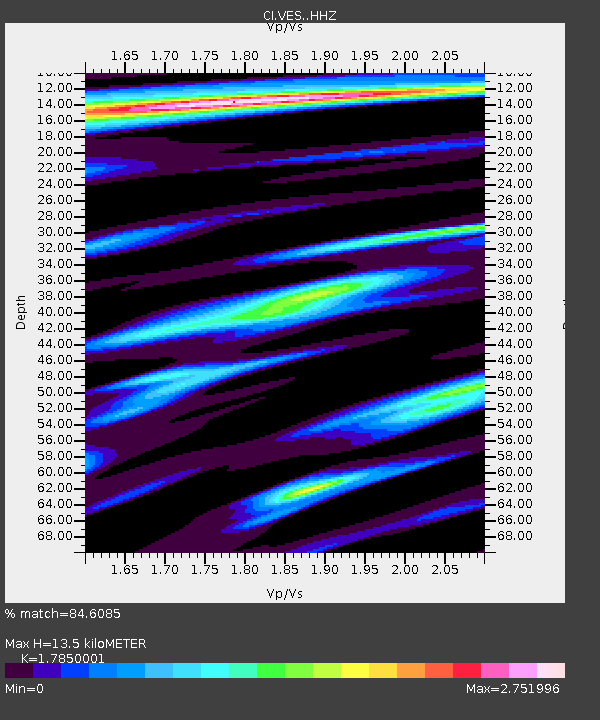
| Estimated Moho Depth: |
13.5 km |
| Estimated Crust Vp/Vs: |
1.79 |
| Assumed Crust Vp: |
6.1 km/s |
| Estimated Crust Vs: |
3.417 km/s |
| Estimated Crust Poisson's Ratio: |
0.27 |
|
| Radial Match: |
84.6085 % |
| Radial Bump: |
387 |
| Transverse Match: |
76.53793 % |
| Transverse Bump: |
393 |
| SOD ConfigId: |
7422571 |
| Insert Time: |
2019-04-19 20:12:23.095 +0000 |
| GWidth: |
2.5 |
| Max Bumps: |
400 |
| Tol: |
0.001 |
|

Signal To Noise
| Channel | StoN | STA | LTA |
| CI:VES: :HHZ:20150716T15:25:54.807971Z | 9.137847 | 1.4973934E-6 | 1.638672E-7 |
| CI:VES: :HHN:20150716T15:25:54.807971Z | 0.4061222 | 2.4117196E-7 | 5.9384087E-7 |
| CI:VES: :HHE:20150716T15:25:54.807971Z | 2.2624748 | 8.1743934E-7 | 3.613032E-7 |
| Arrivals |
| Ps | 1.8 SECOND |
| PpPs | 5.9 SECOND |
| PsPs/PpSs | 7.7 SECOND |


