You are here: Home > Network List > DK - Danish Seismological Network Stations List
> Station NOR Station Nord, Greenland > Earthquake Result Viewer
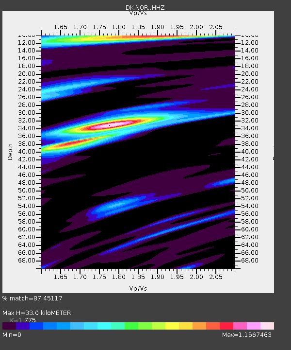
NOR Station Nord, Greenland - Earthquake Result Viewer
| Earthquake location: |
North Atlantic Ocean |
| Earthquake latitude/longitude: |
13.9/-58.5 |
| Earthquake time(UTC): |
2015/07/16 (197) 15:16:32 GMT |
| Earthquake Depth: |
10 km |
| Earthquake Magnitude: |
6.5 MWW, 6.5 MWC, 6.5 MWB, 6.5 MI |
| Earthquake Catalog/Contributor: |
NEIC PDE/NEIC COMCAT |
|
| Network: |
DK Danish Seismological Network |
| Station: |
NOR Station Nord, Greenland |
| Lat/Lon: |
81.60 N/16.66 W |
| Elevation: |
36 m |
|
| Distance: |
70.0 deg |
| Az: |
5.993 deg |
| Baz: |
223.632 deg |
| Ray Param: |
0.055257935 |
| Estimated Moho Depth: |
33.0 km |
| Estimated Crust Vp/Vs: |
1.77 |
| Assumed Crust Vp: |
6.459 km/s |
| Estimated Crust Vs: |
3.639 km/s |
| Estimated Crust Poisson's Ratio: |
0.27 |
|
| Radial Match: |
87.45117 % |
| Radial Bump: |
400 |
| Transverse Match: |
77.36919 % |
| Transverse Bump: |
400 |
| SOD ConfigId: |
7422571 |
| Insert Time: |
2019-04-19 20:14:34.348 +0000 |
| GWidth: |
2.5 |
| Max Bumps: |
400 |
| Tol: |
0.001 |
|

Signal To Noise
| Channel | StoN | STA | LTA |
| DK:NOR: :HHZ:20150716T15:27:12.478992Z | 14.751119 | 1.6371284E-6 | 1.1098334E-7 |
| DK:NOR: :HHN:20150716T15:27:12.478992Z | 5.2551064 | 4.4798432E-7 | 8.524743E-8 |
| DK:NOR: :HHE:20150716T15:27:12.478992Z | 4.423937 | 4.3200612E-7 | 9.765196E-8 |
| Arrivals |
| Ps | 4.1 SECOND |
| PpPs | 14 SECOND |
| PsPs/PpSs | 18 SECOND |


