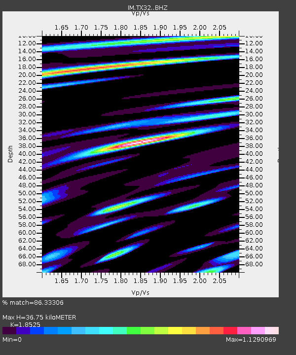
TX32 Lajitas Array Site 32 (same as tx01 and TX00) - Earthquake Result Viewer

Earthquake location: North Atlantic Ocean
Earthquake latitude/longitude: 13.9/-58.5
Earthquake time(UTC): 2015/07/16 (197) 15:16:32 GMT
Earthquake Depth: 10 km
Earthquake Magnitude: 6.5 MWW, 6.5 MWC, 6.5 MWB, 6.5 MI
Earthquake Catalog/Contributor: NEIC PDE/NEIC COMCAT
Network: IM International Miscellaneous Stations
Station: TX32 Lajitas Array Site 32 (same as tx01 and TX00)
Lat/Lon: 29.33 N/103.67 W
Elevation: 996 m
Distance: 44.4 deg
Az: 297.842 deg
Baz: 100.397 deg
Ray Param: 0.0719384
Estimated Moho Depth: 36.75 km
Estimated Crust Vp/Vs: 1.85
Assumed Crust Vp: 6.419 km/s
Estimated Crust Vs: 3.465 km/s
Estimated Crust Poisson's Ratio: 0.29
Radial Match: 86.33306 %
Radial Bump: 400
Transverse Match: 72.77973 %
Transverse Bump: 400
SOD ConfigId: 7422571
Insert Time: 2019-04-19 20:14:35.122 +0000
GWidth: 2.5
Max Bumps: 400
Tol: 0.001

Signal To Noise

ChannelStoNSTALTA
IM:TX32: :BHZ:20150716T15:24:11.499011Z32.190373.7942123E-61.1786793E-7
IM:TX32: :BHN:20150716T15:24:11.499011Z6.48940758.003515E-71.2333197E-7
IM:TX32: :BHE:20150716T15:24:11.499011Z11.2746271.9460078E-61.7260066E-7
Arrivals
Ps5.2 SECOND
PpPs15 SECOND
PsPs/PpSs21 SECOND