You are here: Home > Network List > UU - University of Utah Regional Network Stations List
> Station MTPU Mt. Pierson, UT, USA > Earthquake Result Viewer
MTPU Mt. Pierson, UT, USA - Earthquake Result Viewer
| Earthquake location: |
South Of Panama |
| Earthquake latitude/longitude: |
6.5/-82.7 |
| Earthquake time(UTC): |
2015/03/09 (068) 02:48:45 GMT |
| Earthquake Depth: |
10 km |
| Earthquake Magnitude: |
5.6 MO |
| Earthquake Catalog/Contributor: |
NEIC PDE/NEIC ALERT |
|
| Network: |
UU University of Utah Regional Network |
| Station: |
MTPU Mt. Pierson, UT, USA |
| Lat/Lon: |
38.04 N/112.18 W |
| Elevation: |
3112 m |
|
| Distance: |
41.3 deg |
| Az: |
323.833 deg |
| Baz: |
132.042 deg |
| Ray Param: |
0.07390983 |
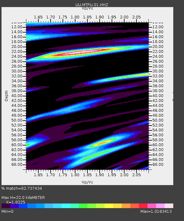
| Estimated Moho Depth: |
22.0 km |
| Estimated Crust Vp/Vs: |
1.82 |
| Assumed Crust Vp: |
6.276 km/s |
| Estimated Crust Vs: |
3.444 km/s |
| Estimated Crust Poisson's Ratio: |
0.28 |
|
| Radial Match: |
82.737434 % |
| Radial Bump: |
340 |
| Transverse Match: |
62.932632 % |
| Transverse Bump: |
400 |
| SOD ConfigId: |
872571 |
| Insert Time: |
2015-03-23 03:08:46.461 +0000 |
| GWidth: |
2.5 |
| Max Bumps: |
400 |
| Tol: |
0.001 |
|

Signal To Noise
| Channel | StoN | STA | LTA |
| UU:MTPU:01:HHZ:20150309T02:55:59.478015Z | 1.4376011 | 9.225063E-9 | 6.416984E-9 |
| UU:MTPU:01:HHN:20150309T02:55:59.478015Z | 0.6926044 | 2.9629281E-9 | 4.2779518E-9 |
| UU:MTPU:01:HHE:20150309T02:55:59.478015Z | 1.3418697 | 4.4836077E-9 | 3.3413137E-9 |
| Arrivals |
| Ps | 3.1 SECOND |
| PpPs | 9.3 SECOND |
| PsPs/PpSs | 12 SECOND |


