You are here: Home > Network List > N4 - Central and EAstern US Network Stations List
> Station L56A Greenwood, NY, USA > Earthquake Result Viewer
L56A Greenwood, NY, USA - Earthquake Result Viewer
| Earthquake location: |
North Atlantic Ocean |
| Earthquake latitude/longitude: |
13.9/-58.5 |
| Earthquake time(UTC): |
2015/07/16 (197) 15:16:32 GMT |
| Earthquake Depth: |
10 km |
| Earthquake Magnitude: |
6.5 MWW, 6.5 MWC, 6.5 MWB, 6.5 MI |
| Earthquake Catalog/Contributor: |
NEIC PDE/NEIC COMCAT |
|
| Network: |
N4 Central and EAstern US Network |
| Station: |
L56A Greenwood, NY, USA |
| Lat/Lon: |
42.14 N/77.56 W |
| Elevation: |
688 m |
|
| Distance: |
32.6 deg |
| Az: |
333.309 deg |
| Baz: |
144.087 deg |
| Ray Param: |
0.078566 |
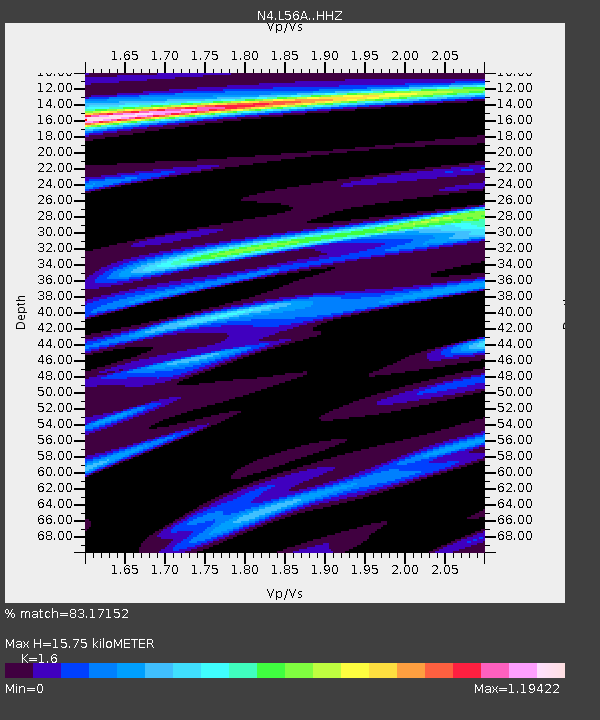
| Estimated Moho Depth: |
15.75 km |
| Estimated Crust Vp/Vs: |
1.60 |
| Assumed Crust Vp: |
6.476 km/s |
| Estimated Crust Vs: |
4.047 km/s |
| Estimated Crust Poisson's Ratio: |
0.18 |
|
| Radial Match: |
83.17152 % |
| Radial Bump: |
400 |
| Transverse Match: |
59.97661 % |
| Transverse Bump: |
400 |
| SOD ConfigId: |
7422571 |
| Insert Time: |
2019-04-19 20:15:43.463 +0000 |
| GWidth: |
2.5 |
| Max Bumps: |
400 |
| Tol: |
0.001 |
|

Signal To Noise
| Channel | StoN | STA | LTA |
| N4:L56A: :HHZ:20150716T15:22:33.240009Z | 2.4820588 | 1.1508184E-6 | 4.636548E-7 |
| N4:L56A: :HHN:20150716T15:22:33.240009Z | 0.9902509 | 3.8030225E-7 | 3.8404636E-7 |
| N4:L56A: :HHE:20150716T15:22:33.240009Z | 2.364899 | 4.959187E-7 | 2.0969973E-7 |
| Arrivals |
| Ps | 1.6 SECOND |
| PpPs | 5.8 SECOND |
| PsPs/PpSs | 7.4 SECOND |


