You are here: Home > Network List > N4 - Central and EAstern US Network Stations List
> Station Q51A Peebles, OH, USA > Earthquake Result Viewer
Q51A Peebles, OH, USA - Earthquake Result Viewer
| Earthquake location: |
North Atlantic Ocean |
| Earthquake latitude/longitude: |
13.9/-58.5 |
| Earthquake time(UTC): |
2015/07/16 (197) 15:16:32 GMT |
| Earthquake Depth: |
10 km |
| Earthquake Magnitude: |
6.5 MWW, 6.5 MWC, 6.5 MWB, 6.5 MI |
| Earthquake Catalog/Contributor: |
NEIC PDE/NEIC COMCAT |
|
| Network: |
N4 Central and EAstern US Network |
| Station: |
Q51A Peebles, OH, USA |
| Lat/Lon: |
39.03 N/83.35 W |
| Elevation: |
362 m |
|
| Distance: |
33.3 deg |
| Az: |
323.461 deg |
| Baz: |
132.065 deg |
| Ray Param: |
0.078281805 |
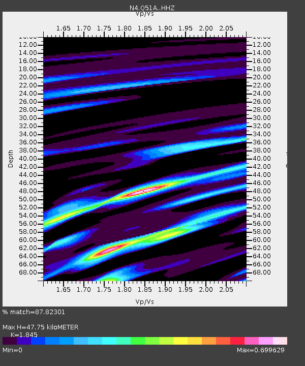
| Estimated Moho Depth: |
47.75 km |
| Estimated Crust Vp/Vs: |
1.85 |
| Assumed Crust Vp: |
6.232 km/s |
| Estimated Crust Vs: |
3.378 km/s |
| Estimated Crust Poisson's Ratio: |
0.29 |
|
| Radial Match: |
87.82301 % |
| Radial Bump: |
253 |
| Transverse Match: |
57.178703 % |
| Transverse Bump: |
400 |
| SOD ConfigId: |
7422571 |
| Insert Time: |
2019-04-19 20:15:56.628 +0000 |
| GWidth: |
2.5 |
| Max Bumps: |
400 |
| Tol: |
0.001 |
|

Signal To Noise
| Channel | StoN | STA | LTA |
| N4:Q51A: :HHZ:20150716T15:22:38.719989Z | 1.8185415 | 3.7883925E-7 | 2.0832037E-7 |
| N4:Q51A: :HHN:20150716T15:22:38.719989Z | 1.7908347 | 3.4215066E-7 | 1.9105653E-7 |
| N4:Q51A: :HHE:20150716T15:22:38.719989Z | 2.366026 | 2.3234296E-7 | 9.819966E-8 |
| Arrivals |
| Ps | 6.9 SECOND |
| PpPs | 20 SECOND |
| PsPs/PpSs | 27 SECOND |


