You are here: Home > Network List > N4 - Central and EAstern US Network Stations List
> Station T47A Sharon Grove, KY, USA > Earthquake Result Viewer
T47A Sharon Grove, KY, USA - Earthquake Result Viewer
| Earthquake location: |
North Atlantic Ocean |
| Earthquake latitude/longitude: |
13.9/-58.5 |
| Earthquake time(UTC): |
2015/07/16 (197) 15:16:32 GMT |
| Earthquake Depth: |
10 km |
| Earthquake Magnitude: |
6.5 MWW, 6.5 MWC, 6.5 MWB, 6.5 MI |
| Earthquake Catalog/Contributor: |
NEIC PDE/NEIC COMCAT |
|
| Network: |
N4 Central and EAstern US Network |
| Station: |
T47A Sharon Grove, KY, USA |
| Lat/Lon: |
36.99 N/87.11 W |
| Elevation: |
217 m |
|
| Distance: |
34.3 deg |
| Az: |
317.282 deg |
| Baz: |
124.622 deg |
| Ray Param: |
0.07778931 |
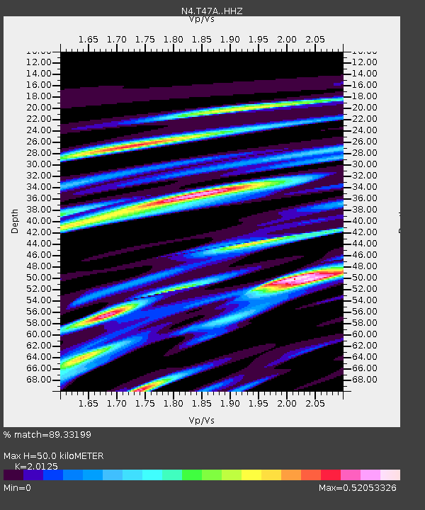
| Estimated Moho Depth: |
50.0 km |
| Estimated Crust Vp/Vs: |
2.01 |
| Assumed Crust Vp: |
6.444 km/s |
| Estimated Crust Vs: |
3.202 km/s |
| Estimated Crust Poisson's Ratio: |
0.34 |
|
| Radial Match: |
89.33199 % |
| Radial Bump: |
310 |
| Transverse Match: |
67.38577 % |
| Transverse Bump: |
400 |
| SOD ConfigId: |
7422571 |
| Insert Time: |
2019-04-19 20:16:05.511 +0000 |
| GWidth: |
2.5 |
| Max Bumps: |
400 |
| Tol: |
0.001 |
|

Signal To Noise
| Channel | StoN | STA | LTA |
| N4:T47A: :HHZ:20150716T15:22:47.93999Z | 4.364379 | 9.748171E-7 | 2.2335759E-7 |
| N4:T47A: :HHN:20150716T15:22:47.93999Z | 1.4052227 | 3.7650992E-7 | 2.6793614E-7 |
| N4:T47A: :HHE:20150716T15:22:47.93999Z | 4.0801325 | 5.0626113E-7 | 1.2407959E-7 |
| Arrivals |
| Ps | 8.4 SECOND |
| PpPs | 22 SECOND |
| PsPs/PpSs | 30 SECOND |


