You are here: Home > Network List > NM - Cooperative New Madrid Seismic Network Stations List
> Station MGMO Mountain Grove, MO > Earthquake Result Viewer
MGMO Mountain Grove, MO - Earthquake Result Viewer
| Earthquake location: |
North Atlantic Ocean |
| Earthquake latitude/longitude: |
13.9/-58.5 |
| Earthquake time(UTC): |
2015/07/16 (197) 15:16:32 GMT |
| Earthquake Depth: |
10 km |
| Earthquake Magnitude: |
6.5 MWW, 6.5 MWC, 6.5 MWB, 6.5 MI |
| Earthquake Catalog/Contributor: |
NEIC PDE/NEIC COMCAT |
|
| Network: |
NM Cooperative New Madrid Seismic Network |
| Station: |
MGMO Mountain Grove, MO |
| Lat/Lon: |
37.15 N/92.27 W |
| Elevation: |
453 m |
|
| Distance: |
37.9 deg |
| Az: |
313.844 deg |
| Baz: |
118.744 deg |
| Ray Param: |
0.07584528 |
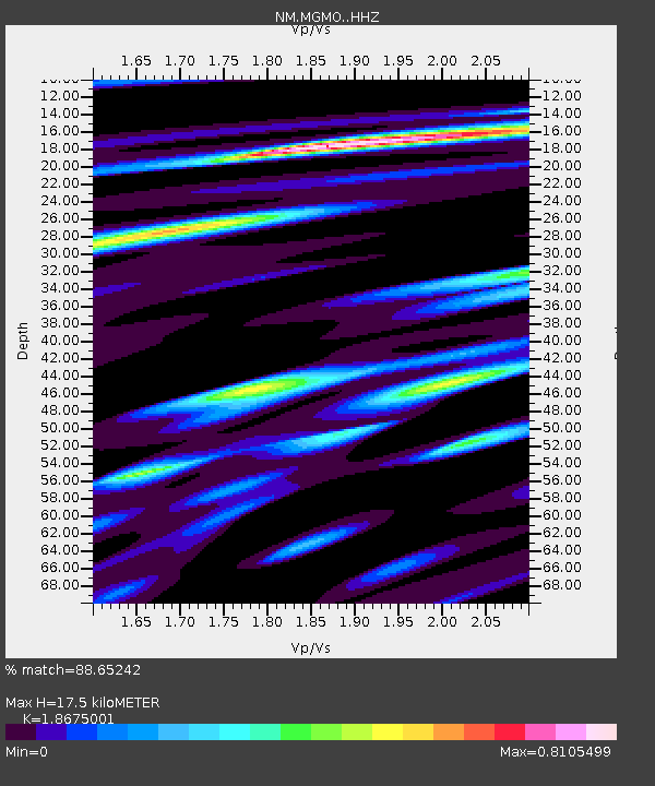
| Estimated Moho Depth: |
17.5 km |
| Estimated Crust Vp/Vs: |
1.87 |
| Assumed Crust Vp: |
6.53 km/s |
| Estimated Crust Vs: |
3.497 km/s |
| Estimated Crust Poisson's Ratio: |
0.30 |
|
| Radial Match: |
88.65242 % |
| Radial Bump: |
309 |
| Transverse Match: |
71.897484 % |
| Transverse Bump: |
400 |
| SOD ConfigId: |
7422571 |
| Insert Time: |
2019-04-19 20:16:32.777 +0000 |
| GWidth: |
2.5 |
| Max Bumps: |
400 |
| Tol: |
0.001 |
|

Signal To Noise
| Channel | StoN | STA | LTA |
| NM:MGMO: :HHZ:20150716T15:23:18.647998Z | 15.7212 | 1.6424603E-6 | 1.0447424E-7 |
| NM:MGMO: :HHN:20150716T15:23:18.647998Z | 5.063317 | 6.824068E-7 | 1.3477465E-7 |
| NM:MGMO: :HHE:20150716T15:23:18.647998Z | 5.609308 | 9.347585E-7 | 1.6664418E-7 |
| Arrivals |
| Ps | 2.5 SECOND |
| PpPs | 7.2 SECOND |
| PsPs/PpSs | 9.7 SECOND |


