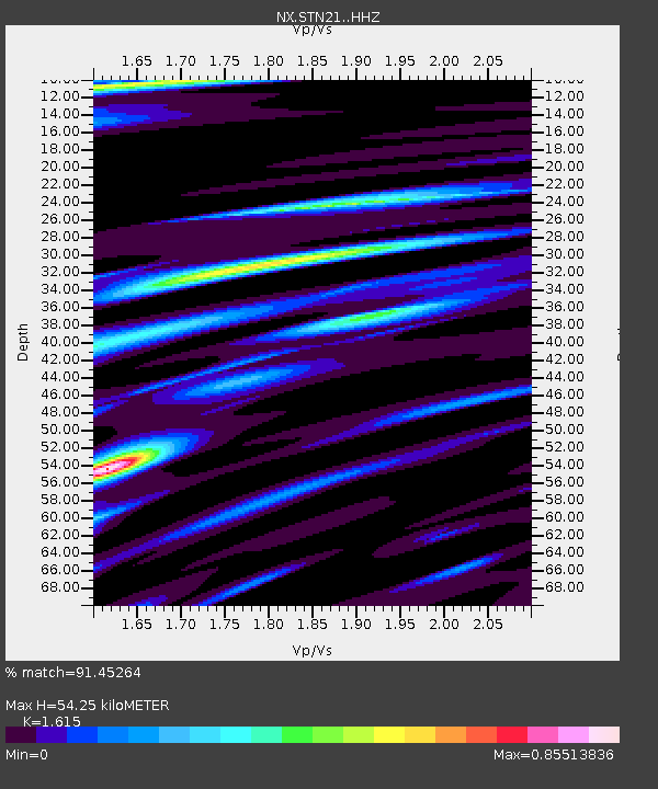
STN21 Seismic station 21 - Earthquake Result Viewer

Earthquake location: North Atlantic Ocean
Earthquake latitude/longitude: 13.9/-58.5
Earthquake time(UTC): 2015/07/16 (197) 15:16:32 GMT
Earthquake Depth: 10 km
Earthquake Magnitude: 6.5 MWW, 6.5 MWC, 6.5 MWB, 6.5 MI
Earthquake Catalog/Contributor: NEIC PDE/NEIC COMCAT
Network: NX Nanometrics Research Network
Station: STN21 Seismic station 21
Lat/Lon: 36.75 N/97.56 W
Elevation: 333 m
Distance: 41.6 deg
Az: 310.393 deg
Baz: 112.92 deg
Ray Param: 0.07369617
Estimated Moho Depth: 54.25 km
Estimated Crust Vp/Vs: 1.62
Assumed Crust Vp: 6.483 km/s
Estimated Crust Vs: 4.014 km/s
Estimated Crust Poisson's Ratio: 0.19
Radial Match: 91.45264 %
Radial Bump: 324
Transverse Match: 65.783966 %
Transverse Bump: 400
SOD ConfigId: 7422571
Insert Time: 2019-04-19 20:17:10.731 +0000
GWidth: 2.5
Max Bumps: 400
Tol: 0.001

Signal To Noise

ChannelStoNSTALTA
NX:STN21: :HHZ:20150716T15:23:48.870013Z21.3867072.5201346E-61.1783649E-7
NX:STN21: :HH1:20150716T15:23:48.870013Z2.39276965.1122976E-72.1365608E-7
NX:STN21: :HH2:20150716T15:23:48.870013Z5.465877.84653E-71.43555E-7
Arrivals
Ps5.6 SECOND
PpPs20 SECOND
PsPs/PpSs26 SECOND