You are here: Home > Network List > PM - Portuguese National Seismic Network Stations List
> Station PESTR ESTREMOZ, PORTUGAL > Earthquake Result Viewer
PESTR ESTREMOZ, PORTUGAL - Earthquake Result Viewer
| Earthquake location: |
North Atlantic Ocean |
| Earthquake latitude/longitude: |
13.9/-58.5 |
| Earthquake time(UTC): |
2015/07/16 (197) 15:16:32 GMT |
| Earthquake Depth: |
10 km |
| Earthquake Magnitude: |
6.5 MWW, 6.5 MWC, 6.5 MWB, 6.5 MI |
| Earthquake Catalog/Contributor: |
NEIC PDE/NEIC COMCAT |
|
| Network: |
PM Portuguese National Seismic Network |
| Station: |
PESTR ESTREMOZ, PORTUGAL |
| Lat/Lon: |
38.87 N/7.59 W |
| Elevation: |
410 m |
|
| Distance: |
51.2 deg |
| Az: |
51.057 deg |
| Baz: |
255.395 deg |
| Ray Param: |
0.06754905 |
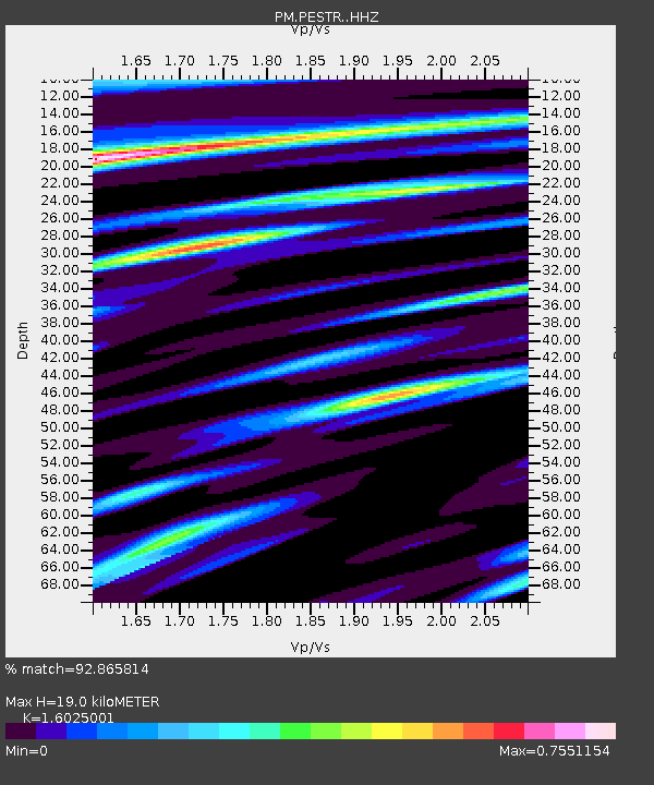
| Estimated Moho Depth: |
19.0 km |
| Estimated Crust Vp/Vs: |
1.60 |
| Assumed Crust Vp: |
6.276 km/s |
| Estimated Crust Vs: |
3.916 km/s |
| Estimated Crust Poisson's Ratio: |
0.18 |
|
| Radial Match: |
92.865814 % |
| Radial Bump: |
352 |
| Transverse Match: |
79.11098 % |
| Transverse Bump: |
400 |
| SOD ConfigId: |
7422571 |
| Insert Time: |
2019-04-19 20:17:47.068 +0000 |
| GWidth: |
2.5 |
| Max Bumps: |
400 |
| Tol: |
0.001 |
|

Signal To Noise
| Channel | StoN | STA | LTA |
| PM:PESTR: :HHZ:20150716T15:25:04.569995Z | 13.344208 | 9.659857E-7 | 7.238988E-8 |
| PM:PESTR: :HHN:20150716T15:25:04.569995Z | 2.479211 | 2.0412476E-7 | 8.233456E-8 |
| PM:PESTR: :HHE:20150716T15:25:04.569995Z | 4.931096 | 4.89495E-7 | 9.926697E-8 |
| Arrivals |
| Ps | 1.9 SECOND |
| PpPs | 7.4 SECOND |
| PsPs/PpSs | 9.4 SECOND |


