You are here: Home > Network List > TA - USArray Transportable Network (new EarthScope stations) Stations List
> Station 435B Jarrell, TX, USA > Earthquake Result Viewer
435B Jarrell, TX, USA - Earthquake Result Viewer

| Earthquake location: |
North Atlantic Ocean |
| Earthquake latitude/longitude: |
13.9/-58.5 |
| Earthquake time(UTC): |
2015/07/16 (197) 15:16:32 GMT |
| Earthquake Depth: |
10 km |
| Earthquake Magnitude: |
6.5 MWW, 6.5 MWC, 6.5 MWB, 6.5 MI |
| Earthquake Catalog/Contributor: |
NEIC PDE/NEIC COMCAT |
|
| Network: |
TA USArray Transportable Network (new EarthScope stations) |
| Station: |
435B Jarrell, TX, USA |
| Lat/Lon: |
30.78 N/97.58 W |
| Elevation: |
248 m |
|
| Distance: |
39.6 deg |
| Az: |
301.761 deg |
| Baz: |
106.346 deg |
| Ray Param: |
0.07488861 |
| Estimated Moho Depth: |
17.0 km |
| Estimated Crust Vp/Vs: |
1.60 |
| Assumed Crust Vp: |
6.347 km/s |
| Estimated Crust Vs: |
3.967 km/s |
| Estimated Crust Poisson's Ratio: |
0.18 |
|
| Radial Match: |
91.804 % |
| Radial Bump: |
400 |
| Transverse Match: |
76.6075 % |
| Transverse Bump: |
400 |
| SOD ConfigId: |
7422571 |
| Insert Time: |
2019-04-19 20:18:20.195 +0000 |
| GWidth: |
2.5 |
| Max Bumps: |
400 |
| Tol: |
0.001 |
|
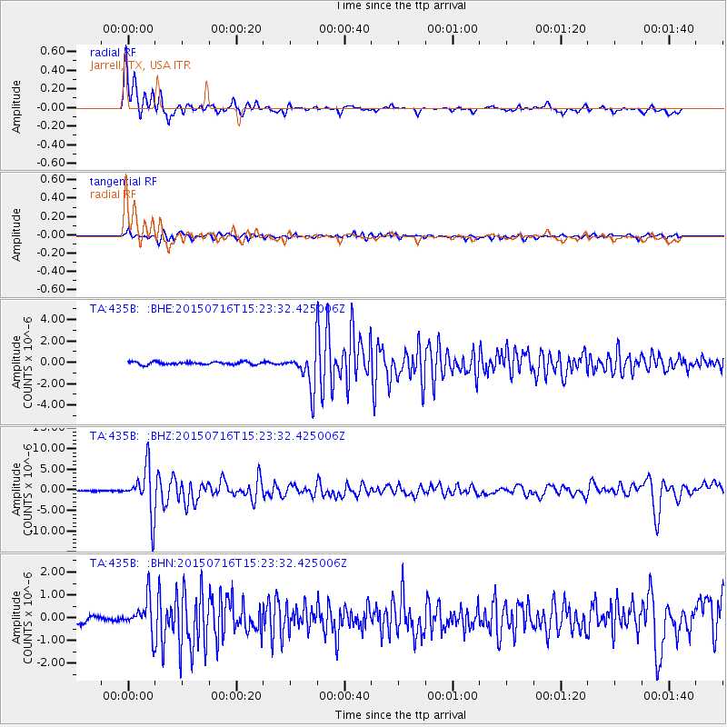
Signal To Noise
| Channel | StoN | STA | LTA |
| TA:435B: :BHZ:20150716T15:23:32.425006Z | 48.17247 | 5.751748E-6 | 1.1939908E-7 |
| TA:435B: :BHN:20150716T15:23:32.425006Z | 5.8310833 | 7.359437E-7 | 1.2621047E-7 |
| TA:435B: :BHE:20150716T15:23:32.425006Z | 17.156233 | 2.2378429E-6 | 1.3043906E-7 |
| Arrivals |
| Ps | 1.7 SECOND |
| PpPs | 6.4 SECOND |
| PsPs/PpSs | 8.2 SECOND |


