You are here: Home > Network List > TA - USArray Transportable Network (new EarthScope stations) Stations List
> Station F61A St Evariste, QC, CAN > Earthquake Result Viewer
F61A St Evariste, QC, CAN - Earthquake Result Viewer
| Earthquake location: |
North Atlantic Ocean |
| Earthquake latitude/longitude: |
13.9/-58.5 |
| Earthquake time(UTC): |
2015/07/16 (197) 15:16:32 GMT |
| Earthquake Depth: |
10 km |
| Earthquake Magnitude: |
6.5 MWW, 6.5 MWC, 6.5 MWB, 6.5 MI |
| Earthquake Catalog/Contributor: |
NEIC PDE/NEIC COMCAT |
|
| Network: |
TA USArray Transportable Network (new EarthScope stations) |
| Station: |
F61A St Evariste, QC, CAN |
| Lat/Lon: |
45.97 N/70.99 W |
| Elevation: |
350 m |
|
| Distance: |
33.7 deg |
| Az: |
344.286 deg |
| Baz: |
157.84 deg |
| Ray Param: |
0.07808871 |
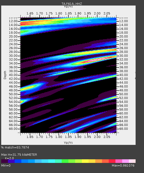
| Estimated Moho Depth: |
31.75 km |
| Estimated Crust Vp/Vs: |
2.00 |
| Assumed Crust Vp: |
6.419 km/s |
| Estimated Crust Vs: |
3.21 km/s |
| Estimated Crust Poisson's Ratio: |
0.33 |
|
| Radial Match: |
83.7874 % |
| Radial Bump: |
400 |
| Transverse Match: |
59.740765 % |
| Transverse Bump: |
400 |
| SOD ConfigId: |
7422571 |
| Insert Time: |
2019-04-19 20:18:40.562 +0000 |
| GWidth: |
2.5 |
| Max Bumps: |
400 |
| Tol: |
0.001 |
|

Signal To Noise
| Channel | StoN | STA | LTA |
| TA:F61A: :HHZ:20150716T15:22:42.490009Z | 7.314378 | 1.5056543E-6 | 2.0584856E-7 |
| TA:F61A: :HHN:20150716T15:22:42.490009Z | 2.662046 | 9.563316E-7 | 3.5924685E-7 |
| TA:F61A: :HHE:20150716T15:22:42.490009Z | 2.3601139 | 6.0972485E-7 | 2.5834552E-7 |
| Arrivals |
| Ps | 5.3 SECOND |
| PpPs | 14 SECOND |
| PsPs/PpSs | 19 SECOND |


