You are here: Home > Network List > TA - USArray Transportable Network (new EarthScope stations) Stations List
> Station G61A St-Isidore-de-Clifton, QC, USA > Earthquake Result Viewer
G61A St-Isidore-de-Clifton, QC, USA - Earthquake Result Viewer

| Earthquake location: |
North Atlantic Ocean |
| Earthquake latitude/longitude: |
13.9/-58.5 |
| Earthquake time(UTC): |
2015/07/16 (197) 15:16:32 GMT |
| Earthquake Depth: |
10 km |
| Earthquake Magnitude: |
6.5 MWW, 6.5 MWC, 6.5 MWB, 6.5 MI |
| Earthquake Catalog/Contributor: |
NEIC PDE/NEIC COMCAT |
|
| Network: |
TA USArray Transportable Network (new EarthScope stations) |
| Station: |
G61A St-Isidore-de-Clifton, QC, USA |
| Lat/Lon: |
45.28 N/71.53 W |
| Elevation: |
378 m |
|
| Distance: |
33.2 deg |
| Az: |
343.172 deg |
| Baz: |
156.529 deg |
| Ray Param: |
0.078315236 |
| Estimated Moho Depth: |
58.0 km |
| Estimated Crust Vp/Vs: |
1.95 |
| Assumed Crust Vp: |
6.419 km/s |
| Estimated Crust Vs: |
3.288 km/s |
| Estimated Crust Poisson's Ratio: |
0.32 |
|
| Radial Match: |
84.33155 % |
| Radial Bump: |
238 |
| Transverse Match: |
65.9927 % |
| Transverse Bump: |
362 |
| SOD ConfigId: |
7422571 |
| Insert Time: |
2019-04-19 20:18:43.517 +0000 |
| GWidth: |
2.5 |
| Max Bumps: |
400 |
| Tol: |
0.001 |
|
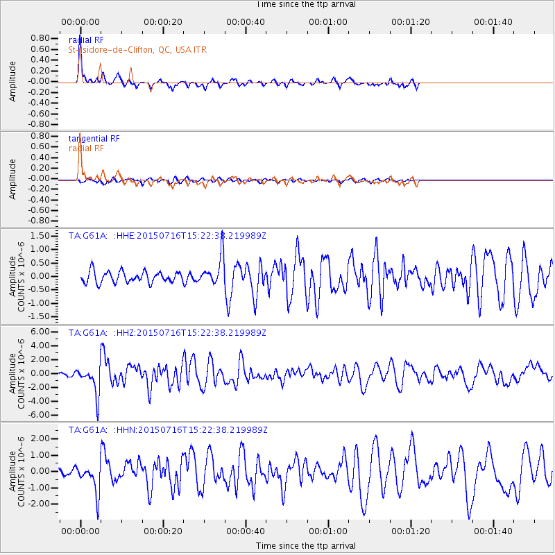
Signal To Noise
| Channel | StoN | STA | LTA |
| TA:G61A: :HHZ:20150716T15:22:38.219989Z | 5.18279 | 2.2325498E-6 | 4.307622E-7 |
| TA:G61A: :HHN:20150716T15:22:38.219989Z | 3.0108616 | 9.787858E-7 | 3.2508495E-7 |
| TA:G61A: :HHE:20150716T15:22:38.219989Z | 2.7100127 | 5.7127824E-7 | 2.1080278E-7 |
| Arrivals |
| Ps | 9.2 SECOND |
| PpPs | 25 SECOND |
| PsPs/PpSs | 34 SECOND |


